Az Zabadānī geodata
Az Zabadānī (Rif-dimashq) is a seat of a second-order administrative division; located in Syria in Asia/Damascus (GMT+3) time zone. With population of 29,549 people, there are 51 cities with bigger population in this country. Compared to other cities in Syria, 78.1% of cities are located further ↑North; 84.5% of cities are located further →East and 95.1% of cities have lower elevation than Az Zabadānī. Note1


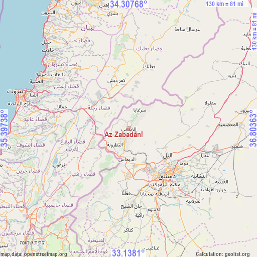
Az Zabadānī GPS coordinates[2]
33° 43' 29.568" North, 36° 6' 1.8" East
| Map corner | latitude | longitude |
|---|---|---|
| Upper-left | 34.30768°, | 35.39738° |
| Center: | 33.72488°, | 36.1005° |
| Lower-right: | 33.1381°, | 36.80363° |
| Map W x H: | 130×130 km | = 80.8×80.8mi |
| max Lat: | 37.17701° ⇑78.1% North |
| Az Zabadānī: | 33.72488° |
| min Lat: | ⇓21.9% South 32.39332° |
| min Long | Az Zabadānī | max Long |
| 35.75572° | 36.1005° | 42.14006° |
| W 15.5%⇐ | ⇒84.5% E |
Elevation
Elevation of Az Zabadānī is 1183 m = 3881 ft, and this is 653.9 m = 2145 ft above average elevation for this country.
| Max E: |
1640 m = 5381 ft | 4.9% |
| Az Zabadānī | 1183 m 3881 ft | |
| Avg. | 529.1 m = 1736 ft | |
Min E: |
4 m = 13 ft | 95.1% |
See also: Syria elevation on elevation.city.
Geographical zone
Az Zabadānī is located in North temperate zone (between Tropic of Cancer and the Arctic Circle). Distance of this Northern Tropic circle is 1143.9 km =710.8 mi to South.| Distance of | km | miles | from Az Zabadānī |
|---|---|---|---|
| North Pole | 6257.2 | 3888 | to North |
| Arctic Circle | 3651.3 | 2268.8 | to North |
| Tropic Cancer | 1143.9 | 710.8 | to South |
| Equator | 3749.9 | 2330.1 | to South |


Nearby cities:
15 places around Az Zabadānī: (largest is in red/bold)
• Ad Dīmās
15.3 km =9.5 mi,  182°
182°
• At Tall
23.3 km =14.5 mi,  123°
123°
• Damascus
29.7 km =18.5 mi,  143°
143°
• Douma
32.7 km =20.3 mi, 121°
• Dārayyā
32.1 km =19.9 mi,  157°
157°
• Medaya
3.9 km =2.4 mi, 175°
• Qadsayyā
22.3 km =13.9 mi,  151°
151°
• Qaţanā
32 km =19.9 mi, 183°
• Rankūs
26.8 km =16.7 mi,  82°
82°
• Sirghāyā
10.9 km =6.8 mi,  29°
29°
• Şaydnāyā
25.3 km =15.7 mi,  97°
97°
• Ḩarastā
30.7 km =19.1 mi,  127°
127°
• ‘Assāl al Ward
32.9 km =20.4 mi,  61°
61°
• ‘Ayn al Fījah
14.4 km =8.9 mi, 147°
• ‘Irbīn
32.3 km =20.1 mi, 130°
Sources, notices
• [Note1] Compared only with cities in Syria existing in our database
• [Src1] Map data: © OpenStreetMap contributors (CC-BY-SA)
• [Src2] Other city data from geonames.org with taken over terms of usage.
• [Src3] Geographical zone / Annual Mean Temperature by Robert A. Rohde @ Wikipedia
