Şalkhad geodata
Şalkhad (As-Suwayda) is a seat of a second-order administrative division; located in Syria in Asia/Damascus (GMT+3) time zone. In our database, there are 87 cities with bigger population. Compared to other cities in Syria, 99.3% of cities are located further ↑North; 58.3% of cities are located further ←West and 98.6% of cities have lower elevation than Şalkhad. Note1


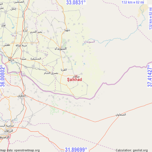
Şalkhad GPS coordinates[2]
32° 29' 31.2" North, 36° 42' 40.104" East
| Map corner | latitude | longitude |
|---|---|---|
| Upper-left | 33.0831°, | 36.00802° |
| Center: | 32.492°, | 36.71114° |
| Lower-right: | 31.89699°, | 37.41427° |
| Map W x H: | 131.9×131.9 km | = 82×82mi |
| max Lat: | 37.17701° ⇑99.3% North |
| Şalkhad: | 32.492° |
| min Lat: | ⇓0.7% South 32.39332° |
| min Long | Şalkhad | max Long |
| 35.75572° | 36.71114° | 42.14006° |
| W 58.3%⇐ | ⇒41.7% E |
Elevation
Elevation of Şalkhad is 1383 m = 4537 ft, and this is 853.9 m = 2802 ft above average elevation for this country.
| Max E: |
1640 m = 5381 ft | 1.4% |
| Şalkhad | 1383 m 4537 ft | |
| Avg. | 529.1 m = 1736 ft | |
Min E: |
4 m = 13 ft | 98.6% |
See also: Syria elevation on elevation.city.
Geographical zone
Şalkhad is located in North temperate zone (between Tropic of Cancer and the Arctic Circle). Distance of this Northern Tropic circle is 1006.9 km =625.7 mi to South.| Distance of | km | miles | from Şalkhad |
|---|---|---|---|
| North Pole | 6394.3 | 3973.2 | to North |
| Arctic Circle | 3788.4 | 2354 | to North |
| Tropic Cancer | 1006.9 | 625.7 | to South |
| Equator | 3612.8 | 2244.9 | to South |


Nearby cities:
15 places around Şalkhad: (largest is in red/bold)
• Al Ghāriyah
12.4 km =7.7 mi,  207°
207°
• Al Jīzah
38.1 km =23.7 mi,  283°
283°
• Al Mazra‘ah
39.2 km =24.4 mi,  325°
325°
• Al Musayfirah
38.2 km =23.7 mi,  294°
294°
• Al Mushannaf
28.1 km =17.5 mi,  12°
12°
• Al Qurayyā
12.1 km =7.5 mi,  298°
298°
• Al Ḩarāk
47.2 km =29.3 mi,  307°
307°
• As-Suwayda
27.5 km =17.1 mi, 331°
• Buşrá ash Shām
21.7 km =13.5 mi, 278°
• Dhībīn
14.9 km =9.3 mi,  246°
246°
• Malaḩ
13.8 km =8.6 mi,  82°
82°
• Shahbā
41.1 km =25.5 mi,  349°
349°
• Shaqqā
45.1 km =28 mi,  358°
358°
• Şalākhid
44.3 km =27.5 mi,  342°
342°
• ‘Arīqah
49.1 km =30.5 mi, 334°
Sources, notices
• [Note1] Compared only with cities in Syria existing in our database
• [Src1] Map data: © OpenStreetMap contributors (CC-BY-SA)
• [Src2] Other city data from geonames.org with taken over terms of usage.
• [Src3] Geographical zone / Annual Mean Temperature by Robert A. Rohde @ Wikipedia
