Kandé geodata
Kandé (Kara) is a populated place; located in Togo in Africa/Lome (GMT+0) time zone. With population of 11,466 people, there are 18 cities with bigger population in this country. Compared to other cities in Togo, 90% of cities are located further ↓South; 65% of cities are located further →East and 60% of cities have higher elevation than Kandé. Note1


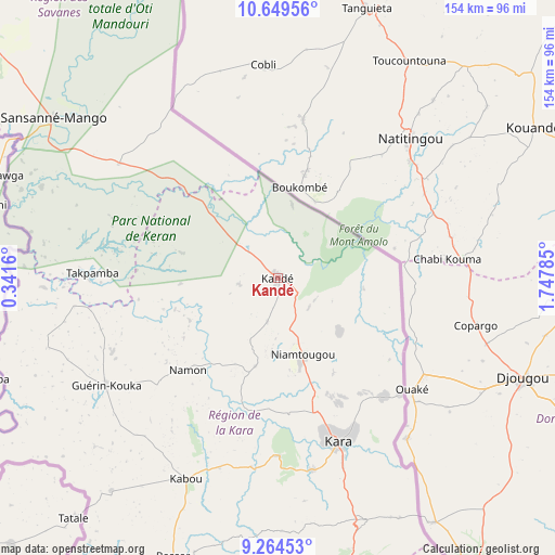
Kandé GPS coordinates[2]
9° 57' 28.008" North, 1° 2' 40.992" East
| Map corner | latitude | longitude |
|---|---|---|
| Upper-left | 10.64956°, | 0.3416° |
| Center: | 9.95778°, | 1.04472° |
| Lower-right: | 9.26453°, | 1.74785° |
| Map W x H: | 154×154 km | = 95.7×95.7mi |
| max Lat: | 10.86225° ⇑10% North |
| Kandé: | 9.95778° |
| min Lat: | ⇓90% South 6.12874° |
| min Long | Kandé | max Long |
| 0.20762° | 1.04472° | 1.5919° |
| W 35%⇐ | ⇒65% E |
Elevation
Elevation of Kandé is 269 m = 883 ft, and this is 1.9 m = 6 ft above average elevation for this country.
| Max E: |
608 m = 1995 ft | 60% |
| Kandé | 269 m 883 ft | |
| Avg. | 267.1 m = 876 ft | |
Min E: |
5 m = 16 ft | 40% |
See also: Togo elevation on elevation.city.
Geographical zone
Kandé is located in North Torrid zone (between Equator and Tropic of Cancer). Distance of Equator is 1107.2 km =688 mi to South.| Distance of | km | miles | from Kandé |
|---|---|---|---|
| North Pole | 8899.9 | 5530.1 | to North |
| Arctic Circle | 6294 | 3910.9 | to North |
| Tropic Cancer | 1498.7 | 931.2 | to North |
| Equator | 1107.2 | 688 | to South |


Nearby cities:
15 places around Kandé: (largest is in red/bold)
• Amlamé
277.4 km =172.4 mi,  183°
183°
• Atakpamé
269.7 km =167.6 mi, 177°
• Badou
268.5 km =166.8 mi,  190°
190°
• Bafilo
71.8 km =44.6 mi,  160°
160°
• Bassar
83.8 km =52.1 mi,  200°
200°
• Dapaong
136 km =84.5 mi,  317°
317°
• Kara
47.8 km =29.7 mi, 161°
• Kpalimé
343 km =213.1 mi, 187°
• Niamtougou
22.1 km =13.7 mi, 162°
• Notsé
334.7 km =208 mi, 177°
• Pagouda
38.5 km =23.9 mi,  126°
126°
• Sansanné-Mango
77.1 km =47.9 mi,  305°
305°
• Sokodé
108.8 km =67.6 mi,  174°
174°
• Sotouboua
155.2 km =96.4 mi, 182°
• Tchamba
110.6 km =68.7 mi, 158°
Sources, notices
• [Note1] Compared only with cities in Togo existing in our database
• [Src1] Map data: © OpenStreetMap contributors (CC-BY-SA)
• [Src2] Other city data from geonames.org with taken over terms of usage.
• [Src3] Geographical zone / Annual Mean Temperature by Robert A. Rohde @ Wikipedia
