Niamtougou geodata
Niamtougou (Kara) is a populated place; located in Togo in Africa/Lome (GMT+0) time zone. With population of 23,261 people, there are 12 cities with bigger population in this country. Compared to other cities in Togo, 85% of cities are located further ↓South; 60% of cities are located further →East and 95% of cities have lower elevation than Niamtougou. Note1


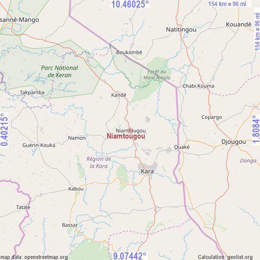
Niamtougou GPS coordinates[2]
9° 46' 5.016" North, 1° 6' 19.008" East
| Map corner | latitude | longitude |
|---|---|---|
| Upper-left | 10.46025°, | 0.40215° |
| Center: | 9.76806°, | 1.10528° |
| Lower-right: | 9.07442°, | 1.8084° |
| Map W x H: | 154.1×154.1 km | = 95.8×95.8mi |
| max Lat: | 10.86225° ⇑15% North |
| Niamtougou: | 9.76806° |
| min Lat: | ⇓85% South 6.12874° |
| min Long | Niamtougou | max Long |
| 0.20762° | 1.10528° | 1.5919° |
| W 40%⇐ | ⇒60% E |
Elevation
Elevation of Niamtougou is 469 m = 1539 ft, and this is 201.9 m = 662 ft above average elevation for this country.
| Max E: |
608 m = 1995 ft | 5% |
| Niamtougou | 469 m 1539 ft | |
| Avg. | 267.1 m = 876 ft | |
Min E: |
5 m = 16 ft | 95% |
See also: Togo elevation on elevation.city.
Geographical zone
Niamtougou is located in North Torrid zone (between Equator and Tropic of Cancer). Distance of Equator is 1086.1 km =674.9 mi to South.| Distance of | km | miles | from Niamtougou |
|---|---|---|---|
| North Pole | 8921 | 5543.3 | to North |
| Arctic Circle | 6315.1 | 3924 | to North |
| Tropic Cancer | 1519.8 | 944.4 | to North |
| Equator | 1086.1 | 674.9 | to South |


Nearby cities:
15 places around Niamtougou: (largest is in red/bold)
• Amlamé
256.9 km =159.6 mi,  185°
185°
• Atakpamé
248.5 km =154.4 mi,  179°
179°
• Badou
249.2 km =154.8 mi, 192°
• Bafilo
49.7 km =30.9 mi,  159°
159°
• Bassar
67.6 km =42 mi,  211°
211°
• Dapaong
156.3 km =97.1 mi,  321°
321°
• Kandé
22.1 km =13.7 mi,  342°
342°
• Kara
25.7 km =16 mi, 159°
• Kpalimé
323.1 km =200.8 mi, 189°
• Notsé
313.4 km =194.7 mi, 178°
• Pagouda
24.4 km =15.2 mi,  94°
94°
• Sansanné-Mango
95.6 km =59.4 mi,  313°
313°
• Sokodé
87.3 km =54.2 mi, 177°
• Sotouboua
134.6 km =83.6 mi, 185°
• Tchamba
88.5 km =55 mi, 157°
Sources, notices
• [Note1] Compared only with cities in Togo existing in our database
• [Src1] Map data: © OpenStreetMap contributors (CC-BY-SA)
• [Src2] Other city data from geonames.org with taken over terms of usage.
• [Src3] Geographical zone / Annual Mean Temperature by Robert A. Rohde @ Wikipedia
