Ko Pha Ngan geodata
Ko Pha Ngan (Surat Thani) is a populated place; located in Thailand in Asia/Bangkok (GMT+7) time zone. With population of 11,846 people, there are 270 cities with bigger population in this country. Compared to other cities in Thailand, 83.4% of cities are located further ↑North; 71.6% of cities are located further →East and 96.7% of cities have lower elevation than Ko Pha Ngan. Note1


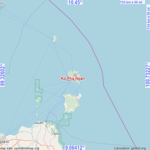
Ko Pha Ngan GPS coordinates[2]
9° 45' 28.008" North, 100° 1' 44.904" East
| Map corner | latitude | longitude |
|---|---|---|
| Upper-left | 10.45°, | 99.32602° |
| Center: | 9.75778°, | 100.02914° |
| Lower-right: | 9.06412°, | 100.73227° |
| Map W x H: | 154.1×154.1 km | = 95.8×95.8mi |
| max Lat: | 20.43353° ⇑83.4% North |
| Ko Pha Ngan: | 9.75778° |
| min Lat: | ⇓16.6% South 5.77434° |
| min Long | Ko Pha Ngan | max Long |
| 97.93288° | 100.02914° | 105.49506° |
| W 28.4%⇐ | ⇒71.6% E |
Elevation
Elevation of Ko Pha Ngan is 430 m = 1411 ft, and this is 304.5 m = 999 ft above average elevation for this country.
| Max E: |
1011 m = 3317 ft | 3.3% |
| Ko Pha Ngan | 430 m 1411 ft | |
| Avg. | 125.5 m = 412 ft | |
Min E: |
1 m = 3 ft | 96.7% |
See also: Thailand elevation on elevation.city.
Geographical zone
Ko Pha Ngan is located in North Torrid zone (between Equator and Tropic of Cancer). Distance of Equator is 1085 km =674.2 mi to South.| Distance of | km | miles | from Ko Pha Ngan |
|---|---|---|---|
| North Pole | 8922.1 | 5543.9 | to North |
| Arctic Circle | 6316.2 | 3924.7 | to North |
| Tropic Cancer | 1521 | 945.1 | to North |
| Equator | 1085 | 674.2 | to South |


Nearby cities:
15 places around Ko Pha Ngan: (largest is in red/bold)
• Chaiya
100 km =62.1 mi,  245°
245°
• Don Sak
61.4 km =38.2 mi,  217°
217°
• Kanchanadit
89.9 km =55.9 mi, 222°
• Ko Pha Ngan
5.7 km =3.5 mi, 221°
• Ko Samui
26.7 km =16.6 mi,  202°
202°
• Koh Tao
43.2 km =26.8 mi,  331°
331°
• Lamae
102.6 km =63.8 mi,  270°
270°
• Lang Suan
106.2 km =66 mi,  281°
281°
• Nopphitam
119.2 km =74.1 mi,  194°
194°
• Sawi
113.9 km =70.8 mi,  297°
297°
• Surat Thani
102.7 km =63.8 mi,  228°
228°
• Tha Chana
96.9 km =60.2 mi,  257°
257°
• Tha Chang
106.9 km =66.4 mi,  239°
239°
• Tha Kham
113.2 km =70.3 mi, 230°
• Thung Tako
110.8 km =68.8 mi,  290°
290°
Sources, notices
• [Note1] Compared only with cities in Thailand existing in our database
• [Src1] Map data: © OpenStreetMap contributors (CC-BY-SA)
• [Src2] Other city data from geonames.org with taken over terms of usage.
• [Src3] Geographical zone / Annual Mean Temperature by Robert A. Rohde @ Wikipedia
