Ko Samui geodata
Ko Samui (Surat Thani) is a seat of a second-order administrative division; located in Thailand in Asia/Bangkok (GMT+7) time zone. With population of 50,000 people, there are 55 cities with bigger population in this country. Compared to other cities in Thailand, 83.8% of cities are located further ↑North; 74.7% of cities are located further →East and 91.2% of cities have higher elevation than Ko Samui. Note1


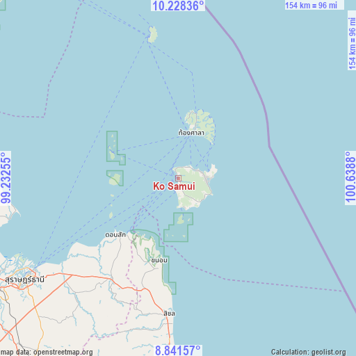
Ko Samui GPS coordinates[2]
9° 32' 8.412" North, 99° 56' 8.412" East
| Map corner | latitude | longitude |
|---|---|---|
| Upper-left | 10.22836°, | 99.23255° |
| Center: | 9.53567°, | 99.93567° |
| Lower-right: | 8.84157°, | 100.6388° |
| Map W x H: | 154.2×154.2 km | = 95.8×95.8mi |
| max Lat: | 20.43353° ⇑83.8% North |
| Ko Samui: | 9.53567° |
| min Lat: | ⇓16.2% South 5.77434° |
| min Long | Ko Samui | max Long |
| 97.93288° | 99.93567° | 105.49506° |
| W 25.3%⇐ | ⇒74.7% E |
Elevation
Elevation of Ko Samui is 8 m = 26 ft, and this is 117.5 m = 385 ft below average elevation for this country.
| Max E: |
1011 m = 3317 ft | 91.2% |
| Avg. | 125.5 m = 412 ft | |
| Ko Samui | 8 m = 26 ft | |
Min E: |
1 m = 3 ft | 8.8% |
See also: Ko Samui elevation on elevation.city.
Geographical zone
Ko Samui is located in North Torrid zone (between Equator and Tropic of Cancer). Distance of Equator is 1060.3 km =658.8 mi to South.| Distance of | km | miles | from Ko Samui |
|---|---|---|---|
| North Pole | 8946.8 | 5559.3 | to North |
| Arctic Circle | 6340.9 | 3940.1 | to North |
| Tropic Cancer | 1545.7 | 960.5 | to North |
| Equator | 1060.3 | 658.8 | to South |


Nearby cities:
15 places around Ko Samui: (largest is in red/bold)
• Ban Na Doem
99.9 km =62.1 mi,  223°
223°
• Ban Na San
103.1 km =64.1 mi, 217°
• Chaiya
82.5 km =51.3 mi,  258°
258°
• Don Sak
36.2 km =22.5 mi,  227°
227°
• Kanchanadit
65.6 km =40.8 mi, 231°
• Ko Pha Ngan
21.4 km =13.3 mi,  17°
17°
• Ko Pha Ngan
26.7 km =16.6 mi, 22°
• Koh Tao
63.4 km =39.4 mi,  350°
350°
• Lamae
96 km =59.7 mi,  285°
285°
• Nopphitam
92.8 km =57.7 mi,  192°
192°
• Surat Thani
79.4 km =49.3 mi,  236°
236°
• Tha Chana
84.5 km =52.5 mi,  272°
272°
• Tha Chang
87 km =54.1 mi,  249°
249°
• Tha Kham
90.5 km =56.2 mi, 238°
• Tha Sala
96.6 km =60 mi,  180°
180°
Sources, notices
• [Note1] Compared only with cities in Thailand existing in our database
• [Src1] Map data: © OpenStreetMap contributors (CC-BY-SA)
• [Src2] Other city data from geonames.org with taken over terms of usage.
• [Src3] Geographical zone / Annual Mean Temperature by Robert A. Rohde @ Wikipedia
