Koh Tao geodata
Koh Tao (Surat Thani) is a populated place; located in Thailand in Asia/Bangkok (GMT+7) time zone. With population of 1,382 people, there are 323 cities with bigger population in this country. Compared to other cities in Thailand, 82.8% of cities are located further ↑North; 78.1% of cities are located further →East and 50.1% of cities have lower elevation than Koh Tao. Note1


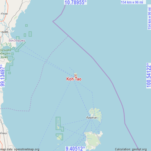
Koh Tao GPS coordinates[2]
10° 5' 53.088" North, 99° 50' 17.124" East
| Map corner | latitude | longitude |
|---|---|---|
| Upper-left | 10.78955°, | 99.13497° |
| Center: | 10.09808°, | 99.83809° |
| Lower-right: | 9.40512°, | 100.54122° |
| Map W x H: | 153.9×153.9 km | = 95.6×95.6mi |
| max Lat: | 20.43353° ⇑82.8% North |
| Koh Tao: | 10.09808° |
| min Lat: | ⇓17.2% South 5.77434° |
| min Long | Koh Tao | max Long |
| 97.93288° | 99.83809° | 105.49506° |
| W 21.9%⇐ | ⇒78.1% E |
Elevation
Elevation of Koh Tao is 95 m = 312 ft, and this is 30.5 m = 100 ft below average elevation for this country.
| Max E: |
1011 m = 3317 ft | 49.9% |
| Avg. | 125.5 m = 412 ft | |
| Koh Tao | 95 m = 312 ft | |
Min E: |
1 m = 3 ft | 50.1% |
See also: Thailand elevation on elevation.city.
Geographical zone
Koh Tao is located in North Torrid zone (between Equator and Tropic of Cancer). Distance of Equator is 1122.8 km =697.7 mi to South.| Distance of | km | miles | from Koh Tao |
|---|---|---|---|
| North Pole | 8884.3 | 5520.4 | to North |
| Arctic Circle | 6278.4 | 3901.2 | to North |
| Tropic Cancer | 1483.1 | 921.6 | to North |
| Equator | 1122.8 | 697.7 | to South |


Nearby cities:
15 places around Koh Tao: (largest is in red/bold)
• Ban Nam Yuen
109.3 km =67.9 mi,  256°
256°
• Chaiya
105.7 km =65.7 mi,  221°
221°
• Chumphon
84.5 km =52.5 mi,  301°
301°
• Don Sak
88.3 km =54.9 mi,  190°
190°
• Kanchanadit
111.2 km =69.1 mi,  201°
201°
• Ko Pha Ngan
43.2 km =26.8 mi,  151°
151°
• Ko Pha Ngan
45.5 km =28.3 mi,  157°
157°
• Ko Samui
63.4 km =39.4 mi,  170°
170°
• Lamae
89.5 km =55.6 mi,  245°
245°
• Lang Suan
84.9 km =52.8 mi, 258°
• Pathio
88.6 km =55.1 mi,  320°
320°
• Sawi
81.2 km =50.5 mi,  280°
280°
• Tha Chana
94 km =58.4 mi,  231°
231°
• Tha Sae
96.2 km =59.8 mi,  310°
310°
• Thung Tako
82.7 km =51.4 mi,  270°
270°
Sources, notices
• [Note1] Compared only with cities in Thailand existing in our database
• [Src1] Map data: © OpenStreetMap contributors (CC-BY-SA)
• [Src2] Other city data from geonames.org with taken over terms of usage.
• [Src3] Geographical zone / Annual Mean Temperature by Robert A. Rohde @ Wikipedia
