Chian Yai geodata
Chian Yai (Nakhon Si Thammarat) is a seat of a second-order administrative division; located in Thailand in Asia/Bangkok (GMT+7) time zone. In our database, there are 331 cities with bigger population. Compared to other cities in Thailand, 88.3% of cities are located further ↑North; 67.8% of cities are located further →East and 94.4% of cities have higher elevation than Chian Yai. Note1


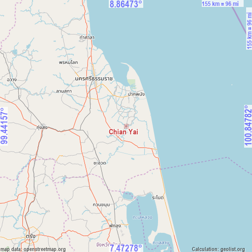
Chian Yai GPS coordinates[2]
8° 10' 9.696" North, 100° 8' 40.884" East
| Map corner | latitude | longitude |
|---|---|---|
| Upper-left | 8.86473°, | 99.44157° |
| Center: | 8.16936°, | 100.14469° |
| Lower-right: | 7.47278°, | 100.84782° |
| Map W x H: | 154.8×154.8 km | = 96.2×96.2mi |
| max Lat: | 20.43353° ⇑88.3% North |
| Chian Yai: | 8.16936° |
| min Lat: | ⇓11.7% South 5.77434° |
| min Long | Chian Yai | max Long |
| 97.93288° | 100.14469° | 105.49506° |
| W 32.2%⇐ | ⇒67.8% E |
Elevation
Elevation of Chian Yai is 7 m = 23 ft, and this is 118.5 m = 389 ft below average elevation for this country.
| Max E: |
1011 m = 3317 ft | 94.4% |
| Avg. | 125.5 m = 412 ft | |
| Chian Yai | 7 m = 23 ft | |
Min E: |
1 m = 3 ft | 5.6% |
See also: Thailand elevation on elevation.city.
Geographical zone
Chian Yai is located in North Torrid zone (between Equator and Tropic of Cancer). Distance of Equator is 908.3 km =564.4 mi to South.| Distance of | km | miles | from Chian Yai |
|---|---|---|---|
| North Pole | 9098.7 | 5653.7 | to North |
| Arctic Circle | 6492.8 | 4034.4 | to North |
| Tropic Cancer | 1697.6 | 1054.8 | to North |
| Equator | 908.3 | 564.4 | to South |


Nearby cities:
15 places around Chian Yai: (largest is in red/bold)
• Cha-uat
27.5 km =17.1 mi,  215°
215°
• Chaloem Phra Kiat
12 km =7.5 mi,  273°
273°
• Chulabhorn
32 km =19.9 mi,  251°
251°
• Hua Sai
22.6 km =14 mi,  128°
128°
• Khuan Khanun
50.6 km =31.4 mi,  197°
197°
• Lan Saka
43.5 km =27 mi,  301°
301°
• Nakhon Si Thammarat
35.3 km =21.9 mi,  326°
326°
• Pa Phayom
44.3 km =27.5 mi,  214°
214°
• Pak Phanang
21.2 km =13.2 mi,  17°
17°
• Phra Phrom
32.8 km =20.4 mi,  305°
305°
• Phrom Khiri
52.9 km =32.9 mi,  318°
318°
• Ranot
47.7 km =29.6 mi,  155°
155°
• Ron Phibun
32 km =19.9 mi, 271°
• Si Banphot
57.5 km =35.7 mi, 209°
• Thung Song
51.1 km =31.8 mi, 269°
Sources, notices
• [Note1] Compared only with cities in Thailand existing in our database
• [Src1] Map data: © OpenStreetMap contributors (CC-BY-SA)
• [Src2] Other city data from geonames.org with taken over terms of usage.
• [Src3] Geographical zone / Annual Mean Temperature by Robert A. Rohde @ Wikipedia
