Pak Phanang geodata
Pak Phanang (Nakhon Si Thammarat) is a seat of a second-order administrative division; located in Thailand in Asia/Bangkok (GMT+7) time zone. With population of 25,014 people, there are 128 cities with bigger population in this country. Compared to other cities in Thailand, 87.6% of cities are located further ↑North; 66.4% of cities are located further →East and 99.3% of cities have higher elevation than Pak Phanang. Note1


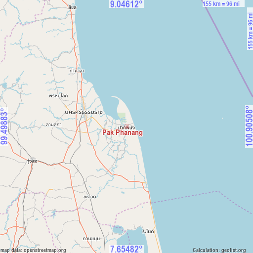
Pak Phanang GPS coordinates[2]
8° 21' 3.924" North, 100° 12' 7.02" East
| Map corner | latitude | longitude |
|---|---|---|
| Upper-left | 9.04612°, | 99.49883° |
| Center: | 8.35109°, | 100.20195° |
| Lower-right: | 7.65482°, | 100.90508° |
| Map W x H: | 154.7×154.7 km | = 96.1×96.1mi |
| max Lat: | 20.43353° ⇑87.6% North |
| Pak Phanang: | 8.35109° |
| min Lat: | ⇓12.4% South 5.77434° |
| min Long | Pak Phanang | max Long |
| 97.93288° | 100.20195° | 105.49506° |
| W 33.6%⇐ | ⇒66.4% E |
Elevation
Elevation of Pak Phanang is 4 m = 13 ft, and this is 121.5 m = 399 ft below average elevation for this country.
| Max E: |
1011 m = 3317 ft | 99.3% |
| Avg. | 125.5 m = 412 ft | |
| Pak Phanang | 4 m = 13 ft | |
Min E: |
1 m = 3 ft | 0.7% |
See also: Thailand elevation on elevation.city.
Geographical zone
Pak Phanang is located in North Torrid zone (between Equator and Tropic of Cancer). Distance of Equator is 928.6 km =577 mi to South.| Distance of | km | miles | from Pak Phanang |
|---|---|---|---|
| North Pole | 9078.5 | 5641.1 | to North |
| Arctic Circle | 6472.6 | 4021.9 | to North |
| Tropic Cancer | 1677.4 | 1042.3 | to North |
| Equator | 928.6 | 577 | to South |


Nearby cities:
15 places around Pak Phanang: (largest is in red/bold)
• Cha-uat
48.1 km =29.9 mi,  207°
207°
• Chaloem Phra Kiat
26.6 km =16.5 mi,  223°
223°
• Chian Yai
21.2 km =13.2 mi,  197°
197°
• Chulabhorn
47.7 km =29.6 mi,  230°
230°
• Hua Sai
36 km =22.4 mi,  161°
161°
• Lan Saka
43.7 km =27.2 mi,  272°
272°
• Nakhon Si Thammarat
27.4 km =17 mi,  289°
289°
• Nopphitam
64.7 km =40.2 mi,  309°
309°
• Pa Phayom
64.8 km =40.3 mi, 208°
• Phra Phrom
33.1 km =20.6 mi, 267°
• Phrom Khiri
45.9 km =28.5 mi, 294°
• Ranot
65.1 km =40.5 mi,  168°
168°
• Ron Phibun
42.8 km =26.6 mi,  243°
243°
• Tha Sala
46.1 km =28.6 mi,  319°
319°
• Thung Song
61 km =37.9 mi,  250°
250°
Sources, notices
• [Note1] Compared only with cities in Thailand existing in our database
• [Src1] Map data: © OpenStreetMap contributors (CC-BY-SA)
• [Src2] Other city data from geonames.org with taken over terms of usage.
• [Src3] Geographical zone / Annual Mean Temperature by Robert A. Rohde @ Wikipedia
