Hua Sai geodata
Hua Sai (Nakhon Si Thammarat) is a seat of a second-order administrative division; located in Thailand in Asia/Bangkok (GMT+7) time zone. In our database, there are 331 cities with bigger population. Compared to other cities in Thailand, 89.3% of cities are located further ↑North; 64.9% of cities are located further →East and 98% of cities have higher elevation than Hua Sai. Note1


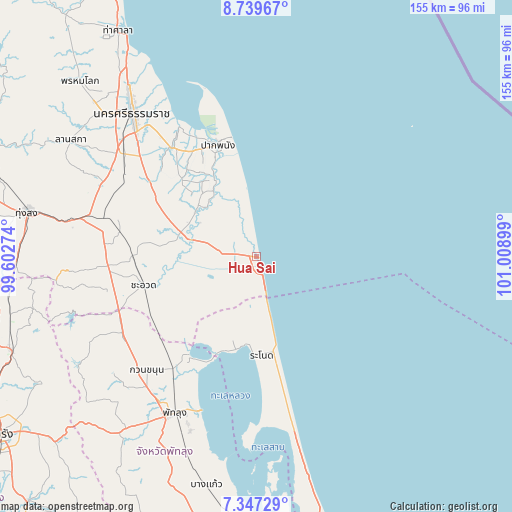
Hua Sai GPS coordinates[2]
8° 2' 38.688" North, 100° 18' 21.096" East
| Map corner | latitude | longitude |
|---|---|---|
| Upper-left | 8.73967°, | 99.60274° |
| Center: | 8.04408°, | 100.30586° |
| Lower-right: | 7.34729°, | 101.00899° |
| Map W x H: | 154.8×154.8 km | = 96.2×96.2mi |
| max Lat: | 20.43353° ⇑89.3% North |
| Hua Sai: | 8.04408° |
| min Lat: | ⇓10.7% South 5.77434° |
| min Long | Hua Sai | max Long |
| 97.93288° | 100.30586° | 105.49506° |
| W 35.1%⇐ | ⇒64.9% E |
Elevation
Elevation of Hua Sai is 5 m = 16 ft, and this is 120.5 m = 395 ft below average elevation for this country.
| Max E: |
1011 m = 3317 ft | 98% |
| Avg. | 125.5 m = 412 ft | |
| Hua Sai | 5 m = 16 ft | |
Min E: |
1 m = 3 ft | 2% |
See also: Thailand elevation on elevation.city.
Geographical zone
Hua Sai is located in North Torrid zone (between Equator and Tropic of Cancer). Distance of Equator is 894.4 km =555.8 mi to South.| Distance of | km | miles | from Hua Sai |
|---|---|---|---|
| North Pole | 9112.6 | 5662.3 | to North |
| Arctic Circle | 6506.8 | 4043.1 | to North |
| Tropic Cancer | 1711.5 | 1063.5 | to North |
| Equator | 894.4 | 555.8 | to South |


Nearby cities:
15 places around Hua Sai: (largest is in red/bold)
• Cha-uat
34.7 km =21.6 mi,  255°
255°
• Chaloem Phra Kiat
33.2 km =20.6 mi,  296°
296°
• Chian Yai
22.6 km =14 mi,  308°
308°
• Chulabhorn
48.2 km =30 mi,  274°
274°
• Khuan Khanun
47.4 km =29.5 mi,  223°
223°
• Krasae Sin
47.7 km =29.6 mi,  177°
177°
• Nakhon Si Thammarat
57.2 km =35.5 mi,  319°
319°
• Pa Phayom
48.4 km =30.1 mi,  242°
242°
• Pak Phanang
36 km =22.4 mi,  341°
341°
• Phatthalung
53.6 km =33.3 mi,  207°
207°
• Phra Phrom
55.3 km =34.4 mi, 306°
• Ranot
29.7 km =18.5 mi, 176°
• Ron Phibun
51.9 km =32.2 mi,  286°
286°
• Sathing Phra
65.2 km =40.5 mi,  166°
166°
• Si Banphot
58.7 km =36.5 mi,  232°
232°
Sources, notices
• [Note1] Compared only with cities in Thailand existing in our database
• [Src1] Map data: © OpenStreetMap contributors (CC-BY-SA)
• [Src2] Other city data from geonames.org with taken over terms of usage.
• [Src3] Geographical zone / Annual Mean Temperature by Robert A. Rohde @ Wikipedia
