Nakhon Thai geodata
Nakhon Thai (Phitsanulok) is a seat of a second-order administrative division; located in Thailand in Asia/Bangkok (GMT+7) time zone. With population of 12,345 people, there are 260 cities with bigger population in this country. Compared to other cities in Thailand, 79.5% of cities are located further ↓South; 51.7% of cities are located further ←West and 83.4% of cities have lower elevation than Nakhon Thai. Note1


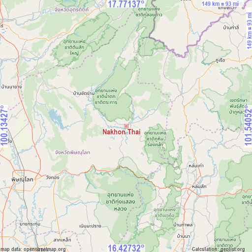
Nakhon Thai GPS coordinates[2]
17° 6' 2.016" North, 100° 50' 14.604" East
| Map corner | latitude | longitude |
|---|---|---|
| Upper-left | 17.77137°, | 100.13427° |
| Center: | 17.10056°, | 100.83739° |
| Lower-right: | 16.42732°, | 101.54052° |
| Map W x H: | 149.4×149.4 km | = 92.8×92.8mi |
| max Lat: | 20.43353° ⇑20.5% North |
| Nakhon Thai: | 17.10056° |
| min Lat: | ⇓79.5% South 5.77434° |
| min Long | Nakhon Thai | max Long |
| 97.93288° | 100.83739° | 105.49506° |
| W 51.7%⇐ | ⇒48.3% E |
Elevation
Elevation of Nakhon Thai is 211 m = 692 ft, and this is 85.5 m = 281 ft above average elevation for this country.
| Max E: |
1011 m = 3317 ft | 16.6% |
| Nakhon Thai | 211 m 692 ft | |
| Avg. | 125.5 m = 412 ft | |
Min E: |
1 m = 3 ft | 83.4% |
See also: Thailand elevation on elevation.city.
Geographical zone
Nakhon Thai is located in North Torrid zone (between Equator and Tropic of Cancer). Distance of this Northern Tropic circle is 704.5 km =437.8 mi to North.| Distance of | km | miles | from Nakhon Thai |
|---|---|---|---|
| North Pole | 8105.7 | 5036.6 | to North |
| Arctic Circle | 5499.8 | 3417.4 | to North |
| Tropic Cancer | 704.5 | 437.8 | to North |
| Equator | 1901.4 | 1181.5 | to South |


Nearby cities:
15 places around Nakhon Thai: (largest is in red/bold)
• Chat Trakan
31.9 km =19.8 mi,  307°
307°
• Dan Sai
38.5 km =23.9 mi,  58°
58°
• Khao Kho
53 km =32.9 mi,  158°
158°
• Lom Kao
48 km =29.8 mi,  119°
119°
• Lom Sak
55.9 km =34.7 mi,  129°
129°
• Na Haeo
49.3 km =30.6 mi,  29°
29°
• Nam Pat
71.6 km =44.5 mi,  346°
346°
• Noen Maprang
63.2 km =39.3 mi,  200°
200°
• Phitsanulok
68.8 km =42.8 mi,  243°
243°
• Phrom Phiram
68 km =42.3 mi,  263°
263°
• Phu Ruea
68.2 km =42.4 mi,  54°
54°
• Sak Lek
76.8 km =47.7 mi,  210°
210°
• Thong Saen Khan
67.7 km =42.1 mi, 307°
• Wang Thong
53.1 km =33 mi,  234°
234°
• Wat Bot
55.3 km =34.4 mi, 256°
Sources, notices
• [Note1] Compared only with cities in Thailand existing in our database
• [Src1] Map data: © OpenStreetMap contributors (CC-BY-SA)
• [Src2] Other city data from geonames.org with taken over terms of usage.
• [Src3] Geographical zone / Annual Mean Temperature by Robert A. Rohde @ Wikipedia
