Mueang Pan geodata
Mueang Pan (Lampang) is a seat of a second-order administrative division; located in Thailand in Asia/Bangkok (GMT+7) time zone. In our database, there are 331 cities with bigger population. Compared to other cities in Thailand, 94.2% of cities are located further ↓South; 85.5% of cities are located further →East and 95.1% of cities have lower elevation than Mueang Pan. Note1


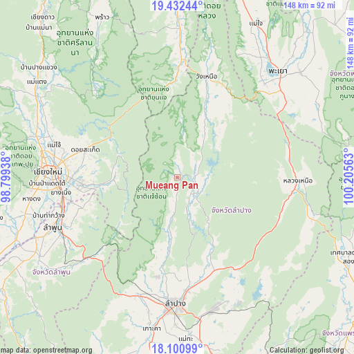
Mueang Pan GPS coordinates[2]
18° 46' 4.908" North, 99° 30' 9" East
| Map corner | latitude | longitude |
|---|---|---|
| Upper-left | 19.43244°, | 98.79938° |
| Center: | 18.76803°, | 99.5025° |
| Lower-right: | 18.10099°, | 100.20563° |
| Map W x H: | 148×148 km | = 92×92mi |
| max Lat: | 20.43353° ⇑5.8% North |
| Mueang Pan: | 18.76803° |
| min Lat: | ⇓94.2% South 5.77434° |
| min Long | Mueang Pan | max Long |
| 97.93288° | 99.5025° | 105.49506° |
| W 14.5%⇐ | ⇒85.5% E |
Elevation
Elevation of Mueang Pan is 393 m = 1289 ft, and this is 267.5 m = 878 ft above average elevation for this country.
| Max E: |
1011 m = 3317 ft | 4.9% |
| Mueang Pan | 393 m 1289 ft | |
| Avg. | 125.5 m = 412 ft | |
Min E: |
1 m = 3 ft | 95.1% |
See also: Thailand elevation on elevation.city.
Geographical zone
Mueang Pan is located in North Torrid zone (between Equator and Tropic of Cancer). Distance of this Northern Tropic circle is 519.1 km =322.6 mi to North.| Distance of | km | miles | from Mueang Pan |
|---|---|---|---|
| North Pole | 7920.3 | 4921.4 | to North |
| Arctic Circle | 5314.4 | 3302.2 | to North |
| Tropic Cancer | 519.1 | 322.6 | to North |
| Equator | 2086.8 | 1296.7 | to South |


Nearby cities:
15 places around Mueang Pan: (largest is in red/bold)
• Ban Thi
43.4 km =27 mi,  249°
249°
• Chae Hom
8.5 km =5.3 mi,  136°
136°
• Chiang Mai
54.6 km =33.9 mi,  272°
272°
• Hang Chat
51.5 km =32 mi,  198°
198°
• Lampang
52.9 km =32.9 mi,  181°
181°
• Lamphun
56.2 km =34.9 mi, 248°
• Mae Mo
56.9 km =35.4 mi,  164°
164°
• Mae On
26.7 km =16.6 mi, 272°
• Mae Tha
50.9 km =31.6 mi,  228°
228°
• Ngao
50.1 km =31.1 mi,  91°
91°
• Phayao
61.5 km =38.2 mi,  40°
40°
• San Kamphaeng
40.4 km =25.1 mi, 266°
• San Sai
49 km =30.4 mi,  280°
280°
• Saraphi
49.6 km =30.8 mi,  263°
263°
• Wang Nuea
43.9 km =27.3 mi,  16°
16°
Sources, notices
• [Note1] Compared only with cities in Thailand existing in our database
• [Src1] Map data: © OpenStreetMap contributors (CC-BY-SA)
• [Src2] Other city data from geonames.org with taken over terms of usage.
• [Src3] Geographical zone / Annual Mean Temperature by Robert A. Rohde @ Wikipedia
