Mae Tha geodata
Mae Tha (Lampang) is a seat of a second-order administrative division; located in Thailand in Asia/Bangkok (GMT+7) time zone. In our database, there are 331 cities with bigger population. Compared to other cities in Thailand, 90.2% of cities are located further ↓South; 85.1% of cities are located further →East and 88.1% of cities have lower elevation than Mae Tha. Note1


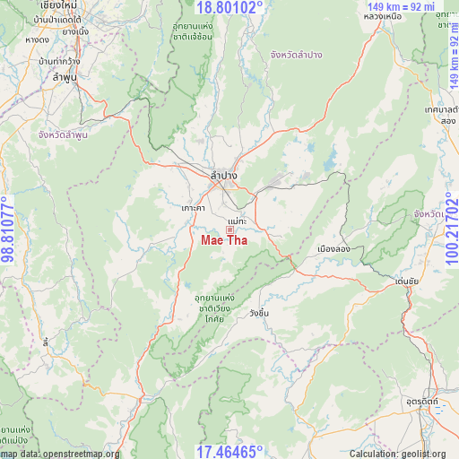
Mae Tha GPS coordinates[2]
18° 8' 2.796" North, 99° 30' 50.004" East
| Map corner | latitude | longitude |
|---|---|---|
| Upper-left | 18.80102°, | 98.81077° |
| Center: | 18.13411°, | 99.51389° |
| Lower-right: | 17.46465°, | 100.21702° |
| Map W x H: | 148.6×148.6 km | = 92.3×92.3mi |
| max Lat: | 20.43353° ⇑9.8% North |
| Mae Tha: | 18.13411° |
| min Lat: | ⇓90.2% South 5.77434° |
| min Long | Mae Tha | max Long |
| 97.93288° | 99.51389° | 105.49506° |
| W 14.9%⇐ | ⇒85.1% E |
Elevation
Elevation of Mae Tha is 250 m = 820 ft, and this is 124.5 m = 408 ft above average elevation for this country.
| Max E: |
1011 m = 3317 ft | 11.9% |
| Mae Tha | 250 m 820 ft | |
| Avg. | 125.5 m = 412 ft | |
Min E: |
1 m = 3 ft | 88.1% |
See also: Thailand elevation on elevation.city.
Geographical zone
Mae Tha is located in North Torrid zone (between Equator and Tropic of Cancer). Distance of this Northern Tropic circle is 589.6 km =366.4 mi to North.| Distance of | km | miles | from Mae Tha |
|---|---|---|---|
| North Pole | 7990.7 | 4965.2 | to North |
| Arctic Circle | 5384.9 | 3346 | to North |
| Tropic Cancer | 589.6 | 366.4 | to North |
| Equator | 2016.3 | 1252.9 | to South |


Nearby cities:
15 places around Mae Tha: (largest is in red/bold)
• Chae Hom
64.5 km =40.1 mi,  4°
4°
• Den Chai
59.3 km =36.8 mi,  106°
106°
• Hang Chat
28 km =17.4 mi,  320°
320°
• Ko Kha
14.2 km =8.8 mi,  297°
297°
• Lampang
17.7 km =11 mi,  352°
352°
• Long
34.1 km =21.2 mi,  101°
101°
• Mae Mo
21.3 km =13.2 mi,  42°
42°
• Mae Tha
53.9 km =33.5 mi,  312°
312°
• Phrae
66.3 km =41.2 mi,  88°
88°
• Soem Ngam
29.4 km =18.3 mi,  254°
254°
• Sop Prap
33.8 km =21 mi,  213°
213°
• Sung Men
64.2 km =39.9 mi, 98°
• Thoen
66 km =41 mi, 208°
• Thung Hua Chang
53.4 km =33.2 mi, 254°
• Wang Chin
30 km =18.6 mi,  160°
160°
Sources, notices
• [Note1] Compared only with cities in Thailand existing in our database
• [Src1] Map data: © OpenStreetMap contributors (CC-BY-SA)
• [Src2] Other city data from geonames.org with taken over terms of usage.
• [Src3] Geographical zone / Annual Mean Temperature by Robert A. Rohde @ Wikipedia
