Ko Kha geodata
Ko Kha (Lampang) is a seat of a second-order administrative division; located in Thailand in Asia/Bangkok (GMT+7) time zone. In our database, there are 331 cities with bigger population. Compared to other cities in Thailand, 90.6% of cities are located further ↓South; 86.7% of cities are located further →East and 86% of cities have lower elevation than Ko Kha. Note1


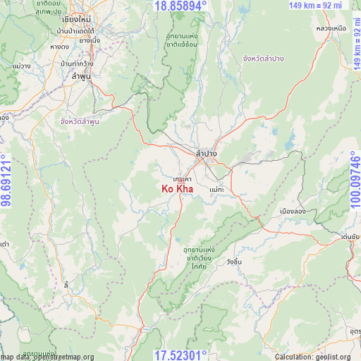
Ko Kha GPS coordinates[2]
18° 11' 32.1" North, 99° 23' 39.588" East
| Map corner | latitude | longitude |
|---|---|---|
| Upper-left | 18.85894°, | 98.69121° |
| Center: | 18.19225°, | 99.39433° |
| Lower-right: | 17.52301°, | 100.09746° |
| Map W x H: | 148.5×148.5 km | = 92.3×92.3mi |
| max Lat: | 20.43353° ⇑9.4% North |
| Ko Kha: | 18.19225° |
| min Lat: | ⇓90.6% South 5.77434° |
| min Long | Ko Kha | max Long |
| 97.93288° | 99.39433° | 105.49506° |
| W 13.3%⇐ | ⇒86.7% E |
Elevation
Elevation of Ko Kha is 223 m = 732 ft, and this is 97.5 m = 320 ft above average elevation for this country.
| Max E: |
1011 m = 3317 ft | 14% |
| Ko Kha | 223 m 732 ft | |
| Avg. | 125.5 m = 412 ft | |
Min E: |
1 m = 3 ft | 86% |
See also: Thailand elevation on elevation.city.
Geographical zone
Ko Kha is located in North Torrid zone (between Equator and Tropic of Cancer). Distance of this Northern Tropic circle is 583.1 km =362.3 mi to North.| Distance of | km | miles | from Ko Kha |
|---|---|---|---|
| North Pole | 7984.3 | 4961.2 | to North |
| Arctic Circle | 5378.4 | 3342 | to North |
| Tropic Cancer | 583.1 | 362.3 | to North |
| Equator | 2022.8 | 1256.9 | to South |


Nearby cities:
15 places around Ko Kha: (largest is in red/bold)
• Ban Hong
62.6 km =38.9 mi,  284°
284°
• Ban Thi
57 km =35.4 mi,  329°
329°
• Chae Hom
60.4 km =37.5 mi,  16°
16°
• Hang Chat
16 km =9.9 mi,  341°
341°
• Lampang
15.2 km =9.4 mi,  43°
43°
• Lamphun
59.4 km =36.9 mi,  316°
316°
• Long
47.9 km =29.8 mi,  105°
105°
• Mae Mo
28.6 km =17.8 mi,  71°
71°
• Mae Tha
14.2 km =8.8 mi,  117°
117°
• Mae Tha
40.4 km =25.1 mi, 318°
• Pa Sang
60.7 km =37.7 mi,  307°
307°
• Soem Ngam
21.2 km =13.2 mi,  228°
228°
• Sop Prap
35.2 km =21.9 mi,  189°
189°
• Thung Hua Chang
44.1 km =27.4 mi,  241°
241°
• Wang Chin
41.5 km =25.8 mi,  146°
146°
Sources, notices
• [Note1] Compared only with cities in Thailand existing in our database
• [Src1] Map data: © OpenStreetMap contributors (CC-BY-SA)
• [Src2] Other city data from geonames.org with taken over terms of usage.
• [Src3] Geographical zone / Annual Mean Temperature by Robert A. Rohde @ Wikipedia
