Phichai geodata
Phichai (Uttaradit) is a seat of a second-order administrative division; located in Thailand in Asia/Bangkok (GMT+7) time zone. In our database, there are 331 cities with bigger population. Compared to other cities in Thailand, 81.6% of cities are located further ↓South; 70% of cities are located further →East and 54.6% of cities have higher elevation than Phichai. Note1


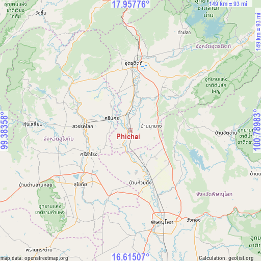
Phichai GPS coordinates[2]
17° 17' 15.504" North, 100° 5' 12.12" East
| Map corner | latitude | longitude |
|---|---|---|
| Upper-left | 17.95776°, | 99.38358° |
| Center: | 17.28764°, | 100.0867° |
| Lower-right: | 16.61507°, | 100.78983° |
| Map W x H: | 149.3×149.3 km | = 92.8×92.8mi |
| max Lat: | 20.43353° ⇑18.4% North |
| Phichai: | 17.28764° |
| min Lat: | ⇓81.6% South 5.77434° |
| min Long | Phichai | max Long |
| 97.93288° | 100.0867° | 105.49506° |
| W 30%⇐ | ⇒70% E |
Elevation
Elevation of Phichai is 60 m = 197 ft, and this is 65.5 m = 215 ft below average elevation for this country.
| Max E: |
1011 m = 3317 ft | 54.6% |
| Avg. | 125.5 m = 412 ft | |
| Phichai | 60 m = 197 ft | |
Min E: |
1 m = 3 ft | 45.4% |
See also: Thailand elevation on elevation.city.
Geographical zone
Phichai is located in North Torrid zone (between Equator and Tropic of Cancer). Distance of this Northern Tropic circle is 683.7 km =424.8 mi to North.| Distance of | km | miles | from Phichai |
|---|---|---|---|
| North Pole | 8084.9 | 5023.7 | to North |
| Arctic Circle | 5479 | 3404.5 | to North |
| Tropic Cancer | 683.7 | 424.8 | to North |
| Equator | 1922.2 | 1194.4 | to South |


Nearby cities:
15 places around Phichai: (largest is in red/bold)
• Ban Na
48.1 km =29.9 mi,  231°
231°
• Chat Trakan
54.5 km =33.9 mi,  91°
91°
• Kong Krailat
39.1 km =24.3 mi,  197°
197°
• Lap Lae
40.8 km =25.4 mi,  352°
352°
• Laplae
40.8 km =25.4 mi, 352°
• Phrom Phiram
30.8 km =19.1 mi,  156°
156°
• Sawankhalok
27.2 km =16.9 mi,  276°
276°
• Si Nakhon
12.7 km =7.9 mi,  302°
302°
• Si Samrong
27.5 km =17.1 mi,  240°
240°
• Si Satchanalai
43 km =26.7 mi,  306°
306°
• Sukhothai
41.9 km =26 mi,  221°
221°
• Thong Saen Khan
33 km =20.5 mi,  51°
51°
• Tron
21.8 km =13.5 mi,  7°
7°
• Uttaradit
37.6 km =23.4 mi,  1°
1°
• Wat Bot
42.9 km =26.7 mi,  142°
142°
Sources, notices
• [Note1] Compared only with cities in Thailand existing in our database
• [Src1] Map data: © OpenStreetMap contributors (CC-BY-SA)
• [Src2] Other city data from geonames.org with taken over terms of usage.
• [Src3] Geographical zone / Annual Mean Temperature by Robert A. Rohde @ Wikipedia
