Sai Yok geodata
Sai Yok (Kanchanaburi) is a seat of a second-order administrative division; located in Thailand in Asia/Bangkok (GMT+7) time zone. In our database, there are 331 cities with bigger population. Compared to other cities in Thailand, 63.4% of cities are located further ↑North; 89.8% of cities are located further →East and 55.3% of cities have higher elevation than Sai Yok. Note1


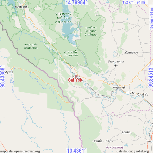
Sai Yok GPS coordinates[2]
14° 7' 8.364" North, 99° 8' 31.2" East
| Map corner | latitude | longitude |
|---|---|---|
| Upper-left | 14.79984°, | 98.43888° |
| Center: | 14.11899°, | 99.142° |
| Lower-right: | 13.4361°, | 99.84513° |
| Map W x H: | 151.6×151.6 km | = 94.2×94.2mi |
| max Lat: | 20.43353° ⇑63.4% North |
| Sai Yok: | 14.11899° |
| min Lat: | ⇓36.6% South 5.77434° |
| min Long | Sai Yok | max Long |
| 97.93288° | 99.142° | 105.49506° |
| W 10.2%⇐ | ⇒89.8% E |
Elevation
Elevation of Sai Yok is 58 m = 190 ft, and this is 67.5 m = 221 ft below average elevation for this country.
| Max E: |
1011 m = 3317 ft | 55.3% |
| Avg. | 125.5 m = 412 ft | |
| Sai Yok | 58 m = 190 ft | |
Min E: |
1 m = 3 ft | 44.7% |
See also: Thailand elevation on elevation.city.
Geographical zone
Sai Yok is located in North Torrid zone (between Equator and Tropic of Cancer). Distance of this Northern Tropic circle is 1036 km =643.7 mi to North.| Distance of | km | miles | from Sai Yok |
|---|---|---|---|
| North Pole | 8437.2 | 5242.6 | to North |
| Arctic Circle | 5831.3 | 3623.4 | to North |
| Tropic Cancer | 1036 | 643.7 | to North |
| Equator | 1569.9 | 975.5 | to South |


Nearby cities:
15 places around Sai Yok: (largest is in red/bold)
• Ban Kha
81.8 km =50.8 mi,  159°
159°
• Ban Pong
86.2 km =53.6 mi,  112°
112°
• Bo Phloi
46.2 km =28.7 mi,  60°
60°
• Chom Bueng
73.7 km =45.8 mi,  138°
138°
• Dan Makham Tia
41.4 km =25.7 mi, 135°
• Huai Krachao
61.2 km =38 mi,  67°
67°
• Kanchanaburi
45.6 km =28.3 mi, 106°
• Nong Prue
64.1 km =39.8 mi,  32°
32°
• Phanom Thuan
60 km =37.3 mi,  88°
88°
• Si Sawat
53.5 km =33.2 mi,  356°
356°
• Suan Phueng
67.5 km =41.9 mi, 161°
• Tha Maka
70.8 km =44 mi, 108°
• Tha Maka
71.7 km =44.6 mi, 109°
• Tha Muang
56.6 km =35.2 mi, 108°
• U Thong
85.7 km =53.3 mi, 70°
Sources, notices
• [Note1] Compared only with cities in Thailand existing in our database
• [Src1] Map data: © OpenStreetMap contributors (CC-BY-SA)
• [Src2] Other city data from geonames.org with taken over terms of usage.
• [Src3] Geographical zone / Annual Mean Temperature by Robert A. Rohde @ Wikipedia
