Tha Maka geodata
Tha Maka (Kanchanaburi) is a populated place; located in Thailand in Asia/Bangkok (GMT+7) time zone. With population of 52,907 people, there are 50 cities with bigger population in this country. Compared to other cities in Thailand, 66.2% of cities are located further ↑North; 79.8% of cities are located further →East and 75.3% of cities have higher elevation than Tha Maka. Note1


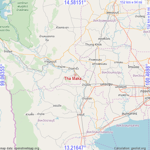
Tha Maka GPS coordinates[2]
13° 54' 0" North, 99° 46' 0.012" East
| Map corner | latitude | longitude |
|---|---|---|
| Upper-left | 14.58151°, | 99.06355° |
| Center: | 13.9°, | 99.76667° |
| Lower-right: | 13.21647°, | 100.4698° |
| Map W x H: | 151.8×151.8 km | = 94.3×94.3mi |
| max Lat: | 20.43353° ⇑66.2% North |
| Tha Maka: | 13.9° |
| min Lat: | ⇓33.8% South 5.77434° |
| min Long | Tha Maka | max Long |
| 97.93288° | 99.76667° | 105.49506° |
| W 20.2%⇐ | ⇒79.8% E |
Elevation
Elevation of Tha Maka is 15 m = 49 ft, and this is 110.5 m = 363 ft below average elevation for this country.
| Max E: |
1011 m = 3317 ft | 75.3% |
| Avg. | 125.5 m = 412 ft | |
| Tha Maka | 15 m = 49 ft | |
Min E: |
1 m = 3 ft | 24.7% |
See also: Tha Maka elevation on elevation.city.
Geographical zone
Tha Maka is located in North Torrid zone (between Equator and Tropic of Cancer). Distance of this Northern Tropic circle is 1060.4 km =658.9 mi to North.| Distance of | km | miles | from Tha Maka |
|---|---|---|---|
| North Pole | 8461.5 | 5257.7 | to North |
| Arctic Circle | 5855.6 | 3638.5 | to North |
| Tropic Cancer | 1060.4 | 658.9 | to North |
| Equator | 1545.5 | 960.3 | to South |


Nearby cities:
15 places around Tha Maka: (largest is in red/bold)
• Ban Pong
15.1 km =9.4 mi,  127°
127°
• Bang Len
45.8 km =28.5 mi,  72°
72°
• Bang Phae
29.1 km =18.1 mi,  142°
142°
• Chom Bueng
36.4 km =22.6 mi,  211°
211°
• Dan Makham Tia
38.8 km =24.1 mi,  262°
262°
• Don Tum
34.4 km =21.4 mi,  78°
78°
• Kamphaeng Saen
26.5 km =16.5 mi, 65°
• Kanchanaburi
26.3 km =16.3 mi,  296°
296°
• Nakhon Pathom
31.3 km =19.4 mi,  106°
106°
• Phanom Thuan
26.6 km =16.5 mi,  343°
343°
• Photharam
24.8 km =15.4 mi,  158°
158°
• Ratchaburi
40.8 km =25.4 mi,  172°
172°
• Song Phi Nong
45.3 km =28.1 mi,  37°
37°
• Tha Maka
2.3 km =1.4 mi,  356°
356°
• Tha Muang
15.2 km =9.4 mi, 296°
Sources, notices
• [Note1] Compared only with cities in Thailand existing in our database
• [Src1] Map data: © OpenStreetMap contributors (CC-BY-SA)
• [Src2] Other city data from geonames.org with taken over terms of usage.
• [Src3] Geographical zone / Annual Mean Temperature by Robert A. Rohde @ Wikipedia
