Bang Saphan Noi geodata
Bang Saphan Noi (Prachuap Khiri Khan) is a seat of a second-order administrative division; located in Thailand in Asia/Bangkok (GMT+7) time zone. In our database, there are 331 cities with bigger population. Compared to other cities in Thailand, 82% of cities are located further ↑North; 86.2% of cities are located further →East and 69.2% of cities have higher elevation than Bang Saphan Noi. Note1


Bang Saphan Noi GPS coordinates[2]
11° 4' 31.26" North, 99° 26' 29.472" East
| Map corner | latitude | longitude |
|---|---|---|
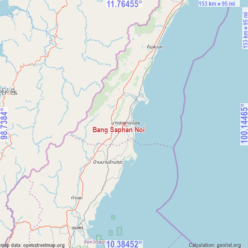
| Upper-left | 11.76455°, | 98.7384° |
| Center: | 11.07535°, | 99.44152° |
| Lower-right: | 10.38452°, | 100.14465° |
| Map W x H: | 153.4×153.4 km | = 95.3×95.3mi |
| max Lat: | 20.43353° ⇑82% North |
| Bang Saphan Noi: | 11.07535° |
| min Lat: | ⇓18% South 5.77434° |
| min Long | Bang Saphan Noi | max Long |
| 97.93288° | 99.44152° | 105.49506° |
| W 13.8%⇐ | ⇒86.2% E |
Elevation
Elevation of Bang Saphan Noi is 24 m = 79 ft, and this is 101.5 m = 333 ft below average elevation for this country.
| Max E: |
1011 m = 3317 ft | 69.2% |
| Avg. | 125.5 m = 412 ft | |
| Bang Saphan Noi | 24 m = 79 ft | |
Min E: |
1 m = 3 ft | 30.8% |
See also: Thailand elevation on elevation.city.
Geographical zone
Bang Saphan Noi is located in North Torrid zone (between Equator and Tropic of Cancer). Distance of Equator is 1231.5 km =765.2 mi to South.| Distance of | km | miles | from Bang Saphan Noi |
|---|---|---|---|
| North Pole | 8775.6 | 5452.9 | to North |
| Arctic Circle | 6169.7 | 3833.7 | to North |
| Tropic Cancer | 1374.5 | 854.1 | to North |
| Equator | 1231.5 | 765.2 | to South |


Nearby cities:
15 places around Bang Saphan Noi: (largest is in red/bold)
• Ban Nam Yuen
147.4 km =91.6 mi,  205°
205°
• Bang Saphan
17.1 km =10.6 mi,  26°
26°
• Chumphon
70.5 km =43.8 mi,  203°
203°
• Koh Tao
117 km =72.7 mi,  158°
158°
• Kra Buri
104.4 km =64.9 mi,  224°
224°
• Kui Buri
120.7 km =75 mi,  21°
21°
• La-Un
130.7 km =81.2 mi, 215°
• Lang Suan
131.7 km =81.8 mi, 197°
• Pathio
42.9 km =26.7 mi, 198°
• Prachuap Khiri Khan
90.9 km =56.5 mi, 24°
• Sam Roi Yot
140.9 km =87.6 mi, 19°
• Sawi
100.1 km =62.2 mi, 201°
• Tha Sae
54.3 km =33.7 mi, 212°
• Thap Sakae
51.1 km =31.8 mi, 22°
• Thung Tako
114.2 km =71 mi, 200°
Sources, notices
• [Note1] Compared only with cities in Thailand existing in our database
• [Src1] Map data: © OpenStreetMap contributors (CC-BY-SA)
• [Src2] Other city data from geonames.org with taken over terms of usage.
• [Src3] Geographical zone / Annual Mean Temperature by Robert A. Rohde @ Wikipedia
