Bang Saphan geodata
Bang Saphan (Prachuap Khiri Khan) is a populated place; located in Thailand in Asia/Bangkok (GMT+7) time zone. With population of 15,134 people, there are 218 cities with bigger population in this country. Compared to other cities in Thailand, 81.9% of cities are located further ↑North; 85.2% of cities are located further →East and 80.8% of cities have higher elevation than Bang Saphan. Note1


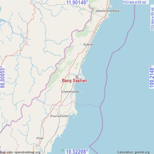
Bang Saphan GPS coordinates[2]
11° 12' 45.324" North, 99° 30' 42.012" East
| Map corner | latitude | longitude |
|---|---|---|
| Upper-left | 11.90146°, | 98.80855° |
| Center: | 11.21259°, | 99.51167° |
| Lower-right: | 10.52208°, | 100.2148° |
| Map W x H: | 153.4×153.4 km | = 95.3×95.3mi |
| max Lat: | 20.43353° ⇑81.9% North |
| Bang Saphan: | 11.21259° |
| min Lat: | ⇓18.1% South 5.77434° |
| min Long | Bang Saphan | max Long |
| 97.93288° | 99.51167° | 105.49506° |
| W 14.8%⇐ | ⇒85.2% E |
Elevation
Elevation of Bang Saphan is 12 m = 39 ft, and this is 113.5 m = 372 ft below average elevation for this country.
| Max E: |
1011 m = 3317 ft | 80.8% |
| Avg. | 125.5 m = 412 ft | |
| Bang Saphan | 12 m = 39 ft | |
Min E: |
1 m = 3 ft | 19.2% |
See also: Thailand elevation on elevation.city.
Geographical zone
Bang Saphan is located in North Torrid zone (between Equator and Tropic of Cancer). Distance of Equator is 1246.7 km =774.7 mi to South.| Distance of | km | miles | from Bang Saphan |
|---|---|---|---|
| North Pole | 8760.3 | 5443.4 | to North |
| Arctic Circle | 6154.5 | 3824.2 | to North |
| Tropic Cancer | 1359.2 | 844.6 | to North |
| Equator | 1246.7 | 774.7 | to South |


Nearby cities:
15 places around Bang Saphan: (largest is in red/bold)
• Bang Saphan Noi
17.1 km =10.6 mi,  206°
206°
• Chumphon
87.6 km =54.4 mi,  204°
204°
• Koh Tao
129 km =80.2 mi,  163°
163°
• Kra Buri
120.8 km =75.1 mi,  221°
221°
• Kui Buri
103.7 km =64.4 mi,  21°
21°
• La-Un
147.6 km =91.7 mi, 214°
• Lang Suan
148.6 km =92.3 mi, 198°
• Pathio
59.8 km =37.2 mi, 200°
• Prachuap Khiri Khan
73.9 km =45.9 mi, 23°
• Pran Buri
137.1 km =85.2 mi, 18°
• Sam Roi Yot
124 km =77.1 mi, 18°
• Sawi
117.1 km =72.8 mi, 202°
• Tha Sae
71.3 km =44.3 mi, 211°
• Thap Sakae
34.1 km =21.2 mi, 20°
• Thung Tako
131.2 km =81.5 mi, 200°
Sources, notices
• [Note1] Compared only with cities in Thailand existing in our database
• [Src1] Map data: © OpenStreetMap contributors (CC-BY-SA)
• [Src2] Other city data from geonames.org with taken over terms of usage.
• [Src3] Geographical zone / Annual Mean Temperature by Robert A. Rohde @ Wikipedia
