Ao Luek geodata
Ao Luek (Krabi) is a seat of a second-order administrative division; located in Thailand in Asia/Bangkok (GMT+7) time zone. With population of 9,628 people, there are 288 cities with bigger population in this country. Compared to other cities in Thailand, 87.3% of cities are located further ↑North; 94.7% of cities are located further →East and 75.3% of cities have higher elevation than Ao Luek. Note1


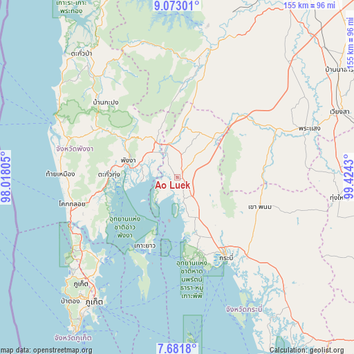
Ao Luek GPS coordinates[2]
8° 22' 40.908" North, 98° 43' 16.212" East
| Map corner | latitude | longitude |
|---|---|---|
| Upper-left | 9.07301°, | 98.01805° |
| Center: | 8.37803°, | 98.72117° |
| Lower-right: | 7.6818°, | 99.4243° |
| Map W x H: | 154.7×154.7 km | = 96.1×96.1mi |
| max Lat: | 20.43353° ⇑87.3% North |
| Ao Luek: | 8.37803° |
| min Lat: | ⇓12.7% South 5.77434° |
| min Long | Ao Luek | max Long |
| 97.93288° | 98.72117° | 105.49506° |
| W 5.3%⇐ | ⇒94.7% E |
Elevation
Elevation of Ao Luek is 15 m = 49 ft, and this is 110.5 m = 363 ft below average elevation for this country.
| Max E: |
1011 m = 3317 ft | 75.3% |
| Avg. | 125.5 m = 412 ft | |
| Ao Luek | 15 m = 49 ft | |
Min E: |
1 m = 3 ft | 24.7% |
See also: Thailand elevation on elevation.city.
Geographical zone
Ao Luek is located in North Torrid zone (between Equator and Tropic of Cancer). Distance of Equator is 931.5 km =578.8 mi to South.| Distance of | km | miles | from Ao Luek |
|---|---|---|---|
| North Pole | 9075.5 | 5639.3 | to North |
| Arctic Circle | 6469.6 | 4020 | to North |
| Tropic Cancer | 1674.4 | 1040.4 | to North |
| Equator | 931.5 | 578.8 | to South |


Nearby cities:
15 places around Ao Luek: (largest is in red/bold)
• Ban Ao Nang
38.2 km =23.7 mi,  165°
165°
• Ban Mai Khao
53.4 km =33.2 mi,  238°
238°
• Ban Phru Nai
49.3 km =30.6 mi,  197°
197°
• Chai Buri
40.2 km =25 mi,  76°
76°
• Kapong
49.3 km =30.6 mi,  315°
315°
• Khao Phanom
38.4 km =23.9 mi,  109°
109°
• Ko Yao
33 km =20.5 mi,  205°
205°
• Krabi
39.8 km =24.7 mi,  148°
148°
• Nuea Khlong
45.8 km =28.5 mi,  138°
138°
• Phang Nga
22.6 km =14 mi,  291°
291°
• Phanom
54 km =33.6 mi,  10°
10°
• Plai Phraya
23.3 km =14.5 mi,  42°
42°
• Takua Thung
29.7 km =18.5 mi,  271°
271°
• Thai Mueang
50.7 km =31.5 mi, 272°
• Thap Put
17.8 km =11.1 mi,  329°
329°
Sources, notices
• [Note1] Compared only with cities in Thailand existing in our database
• [Src1] Map data: © OpenStreetMap contributors (CC-BY-SA)
• [Src2] Other city data from geonames.org with taken over terms of usage.
• [Src3] Geographical zone / Annual Mean Temperature by Robert A. Rohde @ Wikipedia
