Kapong geodata
Kapong (Phangnga) is a seat of a second-order administrative division; located in Thailand in Asia/Bangkok (GMT+7) time zone. In our database, there are 331 cities with bigger population. Compared to other cities in Thailand, 85.7% of cities are located further ↑North; 96.9% of cities are located further →East and 65.8% of cities have higher elevation than Kapong. Note1


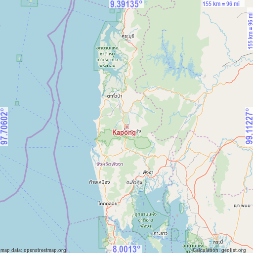
Kapong GPS coordinates[2]
8° 41' 49.092" North, 98° 24' 32.904" East
| Map corner | latitude | longitude |
|---|---|---|
| Upper-left | 9.39135°, | 97.70602° |
| Center: | 8.69697°, | 98.40914° |
| Lower-right: | 8.0013°, | 99.11227° |
| Map W x H: | 154.6×154.6 km | = 96.1×96.1mi |
| max Lat: | 20.43353° ⇑85.7% North |
| Kapong: | 8.69697° |
| min Lat: | ⇓14.3% South 5.77434° |
| min Long | Kapong | max Long |
| 97.93288° | 98.40914° | 105.49506° |
| W 3.1%⇐ | ⇒96.9% E |
Elevation
Elevation of Kapong is 30 m = 98 ft, and this is 95.5 m = 313 ft below average elevation for this country.
| Max E: |
1011 m = 3317 ft | 65.8% |
| Avg. | 125.5 m = 412 ft | |
| Kapong | 30 m = 98 ft | |
Min E: |
1 m = 3 ft | 34.2% |
See also: Thailand elevation on elevation.city.
Geographical zone
Kapong is located in North Torrid zone (between Equator and Tropic of Cancer). Distance of Equator is 967 km =600.9 mi to South.| Distance of | km | miles | from Kapong |
|---|---|---|---|
| North Pole | 9040 | 5617.2 | to North |
| Arctic Circle | 6434.2 | 3998 | to North |
| Tropic Cancer | 1638.9 | 1018.4 | to North |
| Equator | 967 | 600.9 | to South |


Nearby cities:
15 places around Kapong: (largest is in red/bold)
• Ao Luek
49.3 km =30.6 mi,  135°
135°
• Ban Khao Lak
20.7 km =12.9 mi,  243°
243°
• Ban Mai Khao
64.3 km =40 mi,  190°
190°
• Ban Takhun
57.1 km =35.5 mi,  66°
66°
• Khura Buri
55.3 km =34.4 mi,  0°
0°
• Ko Yao
68.3 km =42.4 mi,  162°
162°
• Phang Nga
30.4 km =18.9 mi,  154°
154°
• Phanom
47.7 km =29.6 mi, 68°
• Plai Phraya
53.2 km =33.1 mi,  110°
110°
• Suk Samran
72 km =44.7 mi, 1°
• Takua Pa
20.6 km =12.8 mi,  339°
339°
• Takua Thung
35.1 km =21.8 mi,  172°
172°
• Tha Khanon
70.3 km =43.7 mi,  58°
58°
• Thai Mueang
36.9 km =22.9 mi,  206°
206°
• Thap Put
32.3 km =20.1 mi,  128°
128°
Sources, notices
• [Note1] Compared only with cities in Thailand existing in our database
• [Src1] Map data: © OpenStreetMap contributors (CC-BY-SA)
• [Src2] Other city data from geonames.org with taken over terms of usage.
• [Src3] Geographical zone / Annual Mean Temperature by Robert A. Rohde @ Wikipedia
