Thap Put geodata
Thap Put (Phangnga) is a seat of a second-order administrative division; located in Thailand in Asia/Bangkok (GMT+7) time zone. In our database, there are 331 cities with bigger population. Compared to other cities in Thailand, 86.5% of cities are located further ↑North; 95.2% of cities are located further →East and 65.8% of cities have higher elevation than Thap Put. Note1


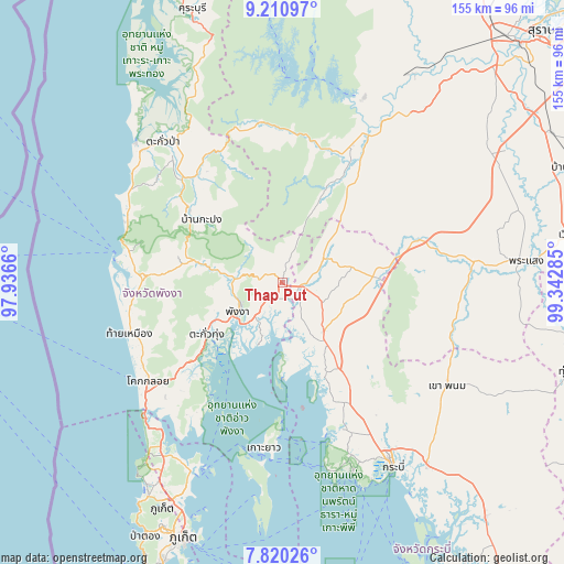
Thap Put GPS coordinates[2]
8° 30' 58.5" North, 98° 38' 22.992" East
| Map corner | latitude | longitude |
|---|---|---|
| Upper-left | 9.21097°, | 97.9366° |
| Center: | 8.51625°, | 98.63972° |
| Lower-right: | 7.82026°, | 99.34285° |
| Map W x H: | 154.6×154.6 km | = 96.1×96.1mi |
| max Lat: | 20.43353° ⇑86.5% North |
| Thap Put: | 8.51625° |
| min Lat: | ⇓13.5% South 5.77434° |
| min Long | Thap Put | max Long |
| 97.93288° | 98.63972° | 105.49506° |
| W 4.8%⇐ | ⇒95.2% E |
Elevation
Elevation of Thap Put is 30 m = 98 ft, and this is 95.5 m = 313 ft below average elevation for this country.
| Max E: |
1011 m = 3317 ft | 65.8% |
| Avg. | 125.5 m = 412 ft | |
| Thap Put | 30 m = 98 ft | |
Min E: |
1 m = 3 ft | 34.2% |
See also: Thailand elevation on elevation.city.
Geographical zone
Thap Put is located in North Torrid zone (between Equator and Tropic of Cancer). Distance of Equator is 946.9 km =588.4 mi to South.| Distance of | km | miles | from Thap Put |
|---|---|---|---|
| North Pole | 9060.1 | 5629.7 | to North |
| Arctic Circle | 6454.3 | 4010.5 | to North |
| Tropic Cancer | 1659 | 1030.9 | to North |
| Equator | 946.9 | 588.4 | to South |


Nearby cities:
15 places around Thap Put: (largest is in red/bold)
• Ao Luek
17.8 km =11.1 mi,  149°
149°
• Ban Ao Nang
55.6 km =34.5 mi,  160°
160°
• Ban Khao Lak
45.3 km =28.1 mi,  284°
284°
• Ban Mai Khao
56.6 km =35.2 mi,  220°
220°
• Ban Takhun
50.8 km =31.6 mi,  31°
31°
• Chai Buri
48.4 km =30.1 mi,  97°
97°
• Kapong
32.3 km =20.1 mi,  308°
308°
• Khao Phanom
53.2 km =33.1 mi,  121°
121°
• Ko Yao
45.5 km =28.3 mi,  186°
186°
• Phang Nga
14.1 km =8.8 mi,  238°
238°
• Phanom
42.2 km =26.2 mi, 26°
• Plai Phraya
24.7 km =15.3 mi,  85°
85°
• Takua Pa
51.1 km =31.8 mi,  320°
320°
• Takua Thung
25.4 km =15.8 mi,  234°
234°
• Thai Mueang
43.7 km =27.2 mi,  252°
252°
Sources, notices
• [Note1] Compared only with cities in Thailand existing in our database
• [Src1] Map data: © OpenStreetMap contributors (CC-BY-SA)
• [Src2] Other city data from geonames.org with taken over terms of usage.
• [Src3] Geographical zone / Annual Mean Temperature by Robert A. Rohde @ Wikipedia
