Pathum Thani geodata
Pathum Thani is a seat of a first-order administrative division; located in Thailand in Asia/Bangkok (GMT+7) time zone. With population of 24,547 people, there are 132 cities with bigger population in this country. Compared to other cities in Thailand, 64.4% of cities are located further ↑North; 56.6% of cities are located further →East and 99.3% of cities have higher elevation than Pathum Thani. Note1


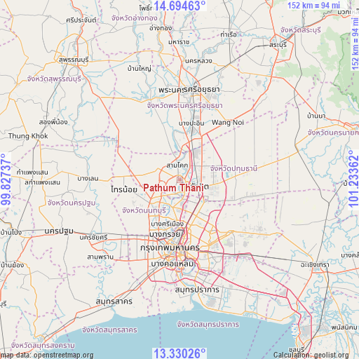
Pathum Thani GPS coordinates[2]
14° 0' 48.456" North, 100° 31' 49.764" East
| Map corner | latitude | longitude |
|---|---|---|
| Upper-left | 14.69463°, | 99.82737° |
| Center: | 14.01346°, | 100.53049° |
| Lower-right: | 13.33026°, | 101.23362° |
| Map W x H: | 151.7×151.7 km | = 94.3×94.3mi |
| max Lat: | 20.43353° ⇑64.4% North |
| Pathum Thani: | 14.01346° |
| min Lat: | ⇓35.6% South 5.77434° |
| min Long | Pathum Thani | max Long |
| 97.93288° | 100.53049° | 105.49506° |
| W 43.4%⇐ | ⇒56.6% E |
Elevation
Elevation of Pathum Thani is 4 m = 13 ft, and this is 121.5 m = 399 ft below average elevation for this country.
| Max E: |
1011 m = 3317 ft | 99.3% |
| Avg. | 125.5 m = 412 ft | |
| Pathum Thani | 4 m = 13 ft | |
Min E: |
1 m = 3 ft | 0.7% |
See also: Thailand elevation on elevation.city.
Geographical zone
Pathum Thani is located in North Torrid zone (between Equator and Tropic of Cancer). Distance of this Northern Tropic circle is 1047.8 km =651.1 mi to North.| Distance of | km | miles | from Pathum Thani |
|---|---|---|---|
| North Pole | 8448.9 | 5249.9 | to North |
| Arctic Circle | 5843 | 3630.7 | to North |
| Tropic Cancer | 1047.8 | 651.1 | to North |
| Equator | 1558.2 | 968.2 | to South |


Nearby cities:
15 places around Pathum Thani: (largest is in red/bold)
• Ban Bang Kadi Pathum Thani
2.6 km =1.6 mi,  127°
127°
• Bang Bua Thong
15.7 km =9.8 mi,  227°
227°
• Bang Kruai
24 km =14.9 mi,  195°
195°
• Bang Pa-in
24.3 km =15.1 mi,  11°
11°
• Bang Sue
22.6 km =14 mi,  178°
178°
• Chatuchak
20.8 km =12.9 mi,  171°
171°
• Don Mueang
12.8 km =8 mi,  149°
149°
• Khlong Luang
13.7 km =8.5 mi,  65°
65°
• Lat Lum Kaeo
13.8 km =8.6 mi,  281°
281°
• Mueang Nonthaburi
17.1 km =10.6 mi,  185°
185°
• Pak Kret
11.7 km =7.3 mi, 197°
• Sai Mai
16.1 km =10 mi, 129°
• Sai Noi
23.9 km =14.9 mi,  260°
260°
• Sam Khok
5.8 km =3.6 mi,  351°
351°
• Thanyaburi
22 km =13.7 mi,  87°
87°
Sources, notices
• [Note1] Compared only with cities in Thailand existing in our database
• [Src1] Map data: © OpenStreetMap contributors (CC-BY-SA)
• [Src2] Other city data from geonames.org with taken over terms of usage.
• [Src3] Geographical zone / Annual Mean Temperature by Robert A. Rohde @ Wikipedia
