Waeng geodata
Waeng (Roi Et) is a seat of a second-order administrative division; located in Thailand in Asia/Bangkok (GMT+7) time zone. With population of 13,317 people, there are 248 cities with bigger population in this country. Compared to other cities in Thailand, 69.4% of cities are located further ↓South; 90.1% of cities are located further ←West and 60.1% of cities have lower elevation than Waeng. Note1


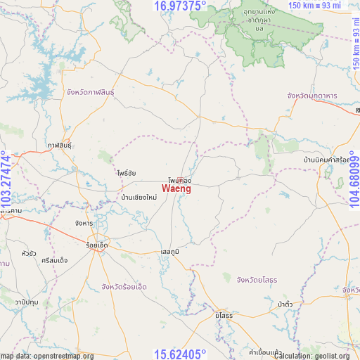
Waeng GPS coordinates[2]
16° 18' 0.216" North, 103° 58' 40.296" East
| Map corner | latitude | longitude |
|---|---|---|
| Upper-left | 16.97375°, | 103.27474° |
| Center: | 16.30006°, | 103.97786° |
| Lower-right: | 15.62405°, | 104.68099° |
| Map W x H: | 150.1×150.1 km | = 93.3×93.3mi |
| max Lat: | 20.43353° ⇑30.6% North |
| Waeng: | 16.30006° |
| min Lat: | ⇓69.4% South 5.77434° |
| min Long | Waeng | max Long |
| 97.93288° | 103.97786° | 105.49506° |
| W 90.1%⇐ | ⇒9.9% E |
Elevation
Elevation of Waeng is 148 m = 486 ft, and this is 22.5 m = 74 ft above average elevation for this country.
| Max E: |
1011 m = 3317 ft | 39.9% |
| Waeng | 148 m 486 ft | |
| Avg. | 125.5 m = 412 ft | |
Min E: |
1 m = 3 ft | 60.1% |
See also: Thailand elevation on elevation.city.
Geographical zone
Waeng is located in North Torrid zone (between Equator and Tropic of Cancer). Distance of this Northern Tropic circle is 793.5 km =493.1 mi to North.| Distance of | km | miles | from Waeng |
|---|---|---|---|
| North Pole | 8194.7 | 5091.9 | to North |
| Arctic Circle | 5588.8 | 3472.7 | to North |
| Tropic Cancer | 793.5 | 493.1 | to North |
| Equator | 1812.4 | 1126.2 | to South |


Nearby cities:
15 places around Waeng: (largest is in red/bold)
• Ban Selaphum
31.7 km =19.7 mi,  185°
185°
• Changhan
43.8 km =27.2 mi,  245°
245°
• Chiang Khwan
28.4 km =17.6 mi,  237°
237°
• Don Chan
34.8 km =21.6 mi,  300°
300°
• Huai Phueng
39.6 km =24.6 mi,  349°
349°
• Kamalasai
43.1 km =26.8 mi,  275°
275°
• Kuchinarai
27.9 km =17.3 mi,  16°
16°
• Moeiwadi
21.6 km =13.4 mi,  62°
62°
• Na Mon
36.9 km =22.9 mi,  326°
326°
• Nong Phok
24 km =14.9 mi,  87°
87°
• Pho Chai
22.4 km =13.9 mi, 278°
• Rong Kham
24.9 km =15.5 mi,  262°
262°
• Selaphum
30.3 km =18.8 mi, 188°
• Thawat Buri
38.2 km =23.7 mi,  220°
220°
• Thung Khao Luang
36.2 km =22.5 mi,  199°
199°
Sources, notices
• [Note1] Compared only with cities in Thailand existing in our database
• [Src1] Map data: © OpenStreetMap contributors (CC-BY-SA)
• [Src2] Other city data from geonames.org with taken over terms of usage.
• [Src3] Geographical zone / Annual Mean Temperature by Robert A. Rohde @ Wikipedia
