Si Thep geodata
Si Thep (Phetchabun) is a seat of a second-order administrative division; located in Thailand in Asia/Bangkok (GMT+7) time zone. In our database, there are 331 cities with bigger population. Compared to other cities in Thailand, 57.5% of cities are located further ↓South; 55.1% of cities are located further ←West and 53.6% of cities have higher elevation than Si Thep. Note1


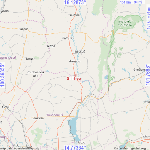
Si Thep GPS coordinates[2]
15° 27' 7.704" North, 101° 4' 0.012" East
| Map corner | latitude | longitude |
|---|---|---|
| Upper-left | 16.12873°, | 100.36355° |
| Center: | 15.45214°, | 101.06667° |
| Lower-right: | 14.77334°, | 101.7698° |
| Map W x H: | 150.7×150.7 km | = 93.6×93.6mi |
| max Lat: | 20.43353° ⇑42.5% North |
| Si Thep: | 15.45214° |
| min Lat: | ⇓57.5% South 5.77434° |
| min Long | Si Thep | max Long |
| 97.93288° | 101.06667° | 105.49506° |
| W 55.1%⇐ | ⇒44.9% E |
Elevation
Elevation of Si Thep is 64 m = 210 ft, and this is 61.5 m = 202 ft below average elevation for this country.
| Max E: |
1011 m = 3317 ft | 53.6% |
| Avg. | 125.5 m = 412 ft | |
| Si Thep | 64 m = 210 ft | |
Min E: |
1 m = 3 ft | 46.4% |
See also: Thailand elevation on elevation.city.
Geographical zone
Si Thep is located in North Torrid zone (between Equator and Tropic of Cancer). Distance of this Northern Tropic circle is 887.8 km =551.7 mi to North.| Distance of | km | miles | from Si Thep |
|---|---|---|---|
| North Pole | 8288.9 | 5150.5 | to North |
| Arctic Circle | 5683.1 | 3531.3 | to North |
| Tropic Cancer | 887.8 | 551.7 | to North |
| Equator | 1718.1 | 1067.6 | to South |


Nearby cities:
15 places around Si Thep: (largest is in red/bold)
• Bueng Sam Phan
44.9 km =27.9 mi,  339°
339°
• Chai Badan
28.9 km =18 mi,  165°
165°
• Khok Charoen
27.8 km =17.3 mi,  253°
253°
• Khok Samrong
56.6 km =35.2 mi,  220°
220°
• Lam Sonthi
36 km =22.4 mi,  117°
117°
• Nong Muang
49.7 km =30.9 mi,  242°
242°
• Nong Phai
59.8 km =37.2 mi,  359°
359°
• Phai Sali
47.6 km =29.6 mi,  290°
290°
• Sa Bot
36.9 km =22.9 mi, 223°
• Sap Yai
62.4 km =38.8 mi,  70°
70°
• Tak Fa
62.3 km =38.7 mi,  259°
259°
• Tha Luang
42.5 km =26.4 mi,  175°
175°
• Thep Sathit
41.7 km =25.9 mi,  99°
99°
• Thepharak
54.3 km =33.7 mi,  107°
107°
• Wichian Buri
23.3 km =14.5 mi,  10°
10°
Sources, notices
• [Note1] Compared only with cities in Thailand existing in our database
• [Src1] Map data: © OpenStreetMap contributors (CC-BY-SA)
• [Src2] Other city data from geonames.org with taken over terms of usage.
• [Src3] Geographical zone / Annual Mean Temperature by Robert A. Rohde @ Wikipedia
