Rong Kwang geodata
Rong Kwang (Phrae) is a seat of a second-order administrative division; located in Thailand in Asia/Bangkok (GMT+7) time zone. With population of 12,087 people, there are 267 cities with bigger population in this country. Compared to other cities in Thailand, 91.9% of cities are located further ↓South; 64.2% of cities are located further →East and 84.1% of cities have lower elevation than Rong Kwang. Note1


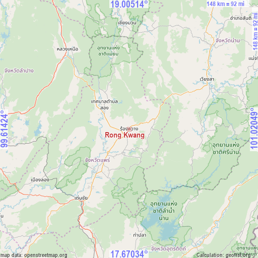
Rong Kwang GPS coordinates[2]
18° 20' 20.508" North, 100° 19' 2.496" East
| Map corner | latitude | longitude |
|---|---|---|
| Upper-left | 19.00514°, | 99.61424° |
| Center: | 18.33903°, | 100.31736° |
| Lower-right: | 17.67034°, | 101.02049° |
| Map W x H: | 148.4×148.4 km | = 92.2×92.2mi |
| max Lat: | 20.43353° ⇑8.1% North |
| Rong Kwang: | 18.33903° |
| min Lat: | ⇓91.9% South 5.77434° |
| min Long | Rong Kwang | max Long |
| 97.93288° | 100.31736° | 105.49506° |
| W 35.8%⇐ | ⇒64.2% E |
Elevation
Elevation of Rong Kwang is 212 m = 696 ft, and this is 86.5 m = 284 ft above average elevation for this country.
| Max E: |
1011 m = 3317 ft | 15.9% |
| Rong Kwang | 212 m 696 ft | |
| Avg. | 125.5 m = 412 ft | |
Min E: |
1 m = 3 ft | 84.1% |
See also: Thailand elevation on elevation.city.
Geographical zone
Rong Kwang is located in North Torrid zone (between Equator and Tropic of Cancer). Distance of this Northern Tropic circle is 566.8 km =352.2 mi to North.| Distance of | km | miles | from Rong Kwang |
|---|---|---|---|
| North Pole | 7968 | 4951.1 | to North |
| Arctic Circle | 5362.1 | 3331.9 | to North |
| Tropic Cancer | 566.8 | 352.2 | to North |
| Equator | 2039.1 | 1267 | to South |


Nearby cities:
15 places around Rong Kwang: (largest is in red/bold)
• Ban Luang
58.2 km =36.2 mi,  12°
12°
• Chiang Muan
61.2 km =38 mi,  358°
358°
• Den Chai
48.4 km =30.1 mi,  215°
215°
• Long
59.2 km =36.8 mi,  240°
240°
• Na Muen
39.9 km =24.8 mi,  114°
114°
• Na Noi
41.9 km =26 mi,  91°
91°
• Nan
69.4 km =43.1 mi,  44°
44°
• Ngao
58.6 km =36.4 mi,  322°
322°
• Nong Muang Khai
15.8 km =9.8 mi, 238°
• Phrae
28.4 km =17.6 mi, 220°
• Phu Phiang
67.8 km =42.1 mi,  48°
48°
• Song
20.5 km =12.7 mi, 316°
• Sung Men
38.7 km =24 mi,  213°
213°
• Tha Pla
61.2 km =38 mi,  174°
174°
• Wiang Sa
53.2 km =33.1 mi,  57°
57°
Sources, notices
• [Note1] Compared only with cities in Thailand existing in our database
• [Src1] Map data: © OpenStreetMap contributors (CC-BY-SA)
• [Src2] Other city data from geonames.org with taken over terms of usage.
• [Src3] Geographical zone / Annual Mean Temperature by Robert A. Rohde @ Wikipedia
