Mŭ’minobod geodata
Mŭ’minobod (Khatlon) is a seat of a second-order administrative division; located in Tajikistan in Asia/Dushanbe (GMT+5) time zone. With population of 11,955 people, there are 29 cities with bigger population in this country. Compared to other cities in Tajikistan, 64.8% of cities are located further ↑North; 75% of cities are located further ←West and 67% of cities have lower elevation than Mŭ’minobod. Note1


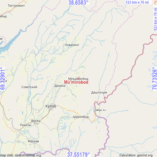
Mŭ’minobod GPS coordinates[2]
38° 6' 25.704" North, 70° 1' 55.668" East
| Map corner | latitude | longitude |
|---|---|---|
| Upper-left | 38.6583°, | 69.32901° |
| Center: | 38.10714°, | 70.03213° |
| Lower-right: | 37.55179°, | 70.73526° |
| Map W x H: | 123×123 km | = 76.4×76.4mi |
| max Lat: | 40.99827° ⇑64.8% North |
| Mŭ’minobod: | 38.10714° |
| min Lat: | ⇓35.2% South 36.72484° |
| min Long | Mŭ’minobod | max Long |
| 67.60931° | 70.03213° | 73.96674° |
| W 75%⇐ | ⇒25% E |
Elevation
Elevation of Mŭ’minobod is 1247 m = 4091 ft, and this is 284.5 m = 933 ft above average elevation for this country.
| Max E: |
3607 m = 11834 ft | 33% |
| Mŭ’minobod | 1247 m 4091 ft | |
| Avg. | 962.5 m = 3158 ft | |
Min E: |
324 m = 1063 ft | 67% |
See also: Tajikistan elevation on elevation.city.
Geographical zone
Mŭ’minobod is located in North temperate zone (between Tropic of Cancer and the Arctic Circle). Distance of this Northern Tropic circle is 1631.2 km =1013.6 mi to South.| Distance of | km | miles | from Mŭ’minobod |
|---|---|---|---|
| North Pole | 5769.9 | 3585.2 | to North |
| Arctic Circle | 3164.1 | 1966.1 | to North |
| Tropic Cancer | 1631.2 | 1013.6 | to South |
| Equator | 4237.1 | 2632.8 | to South |


Nearby cities:
15 places around Mŭ’minobod: (largest is in red/bold)
• Baljuvon
38.3 km =23.8 mi,  305°
305°
• Chubek
61.8 km =38.4 mi,  207°
207°
• Danghara
60.6 km =37.7 mi,  268°
268°
• Khovaling
26.6 km =16.5 mi,  349°
349°
• Kŭlob
30.5 km =19 mi,  225°
225°
• Moskva
61 km =37.9 mi,  215°
215°
• Norak
69.4 km =43.1 mi,  296°
296°
• Obigarm
73.5 km =45.7 mi,  337°
337°
• Qalaikhumb
76.5 km =47.5 mi,  59°
59°
• Roghun
70.1 km =43.6 mi, 338°
• Roghun
76.4 km =47.5 mi, 349°
• Shŭrobod
29.6 km =18.4 mi,  177°
177°
• Sovet
39.4 km =24.5 mi,  260°
260°
• Tavildara
76.3 km =47.4 mi,  31°
31°
• Vose’
47.9 km =29.8 mi, 225°
Sources, notices
• [Note1] Compared only with cities in Tajikistan existing in our database
• [Src1] Map data: © OpenStreetMap contributors (CC-BY-SA)
• [Src2] Other city data from geonames.org with taken over terms of usage.
• [Src3] Geographical zone / Annual Mean Temperature by Robert A. Rohde @ Wikipedia
