Shŭrobod geodata
Shŭrobod (Khatlon) is a seat of a second-order administrative division; located in Tajikistan in Asia/Dushanbe (GMT+5) time zone. In our database, there are 65 cities with bigger population. Compared to other cities in Tajikistan, 73.9% of cities are located further ↑North; 76.1% of cities are located further ←West and 92% of cities have lower elevation than Shŭrobod. Note1


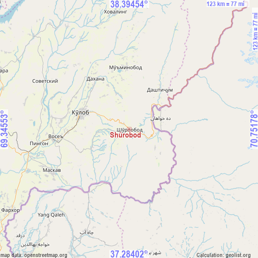
Shŭrobod GPS coordinates[2]
37° 50' 28.932" North, 70° 2' 55.14" East
| Map corner | latitude | longitude |
|---|---|---|
| Upper-left | 38.39454°, | 69.34553° |
| Center: | 37.84137°, | 70.04865° |
| Lower-right: | 37.28402°, | 70.75178° |
| Map W x H: | 123.5×123.5 km | = 76.7×76.7mi |
| max Lat: | 40.99827° ⇑73.9% North |
| Shŭrobod: | 37.84137° |
| min Lat: | ⇓26.1% South 36.72484° |
| min Long | Shŭrobod | max Long |
| 67.60931° | 70.04865° | 73.96674° |
| W 76.1%⇐ | ⇒23.9% E |
Elevation
Elevation of Shŭrobod is 1979 m = 6493 ft, and this is 1016.5 m = 3335 ft above average elevation for this country.
| Max E: |
3607 m = 11834 ft | 8% |
| Shŭrobod | 1979 m 6493 ft | |
| Avg. | 962.5 m = 3158 ft | |
Min E: |
324 m = 1063 ft | 92% |
See also: Tajikistan elevation on elevation.city.
Geographical zone
Shŭrobod is located in North temperate zone (between Tropic of Cancer and the Arctic Circle). Distance of this Northern Tropic circle is 1601.6 km =995.2 mi to South.| Distance of | km | miles | from Shŭrobod |
|---|---|---|---|
| North Pole | 5799.5 | 3603.6 | to North |
| Arctic Circle | 3193.6 | 1984.4 | to North |
| Tropic Cancer | 1601.6 | 995.2 | to South |
| Equator | 4207.6 | 2614.5 | to South |


Nearby cities:
15 places around Shŭrobod: (largest is in red/bold)
• Baljuvon
61.3 km =38.1 mi,  327°
327°
• Chubek
39.3 km =24.4 mi,  230°
230°
• Danghara
68.3 km =42.4 mi,  294°
294°
• Farkhor
68.8 km =42.8 mi,  235°
235°
• Fayzobod
101.1 km =62.8 mi,  320°
320°
• Khovaling
56 km =34.8 mi,  353°
353°
• Kŭlob
24.6 km =15.3 mi, 289°
• Moskva
42 km =26.1 mi, 241°
• Mŭ’minobod
29.6 km =18.4 mi,  357°
357°
• Norak
88 km =54.7 mi,  313°
313°
• Qalaikhumb
94 km =58.4 mi,  43°
43°
• Roghun
98.6 km =61.3 mi,  343°
343°
• Sarband
98.9 km =61.5 mi,  271°
271°
• Sovet
46.4 km =28.8 mi,  299°
299°
• Vose’
35.8 km =22.2 mi,  263°
263°
Sources, notices
• [Note1] Compared only with cities in Tajikistan existing in our database
• [Src1] Map data: © OpenStreetMap contributors (CC-BY-SA)
• [Src2] Other city data from geonames.org with taken over terms of usage.
• [Src3] Geographical zone / Annual Mean Temperature by Robert A. Rohde @ Wikipedia
