Baljuvon geodata
Baljuvon (Khatlon) is a seat of a second-order administrative division; located in Tajikistan in Asia/Dushanbe (GMT+5) time zone. In our database, there are 65 cities with bigger population. Compared to other cities in Tajikistan, 61.4% of cities are located further ↑North; 60.2% of cities are located further ←West and 60.2% of cities have lower elevation than Baljuvon. Note1


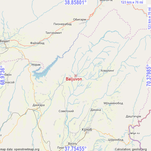
Baljuvon GPS coordinates[2]
38° 18' 30.168" North, 69° 40' 36.192" East
| Map corner | latitude | longitude |
|---|---|---|
| Upper-left | 38.85801°, | 68.9736° |
| Center: | 38.30838°, | 69.67672° |
| Lower-right: | 37.75455°, | 70.37985° |
| Map W x H: | 122.7×122.7 km | = 76.2×76.2mi |
| max Lat: | 40.99827° ⇑61.4% North |
| Baljuvon: | 38.30838° |
| min Lat: | ⇓38.6% South 36.72484° |
| min Long | Baljuvon | max Long |
| 67.60931° | 69.67672° | 73.96674° |
| W 60.2%⇐ | ⇒39.8% E |
Elevation
Elevation of Baljuvon is 915 m = 3002 ft, and this is 47.5 m = 156 ft below average elevation for this country.
| Max E: |
3607 m = 11834 ft | 39.8% |
| Avg. | 962.5 m = 3158 ft | |
| Baljuvon | 915 m = 3002 ft | |
Min E: |
324 m = 1063 ft | 60.2% |
See also: Tajikistan elevation on elevation.city.
Geographical zone
Baljuvon is located in North temperate zone (between Tropic of Cancer and the Arctic Circle). Distance of this Northern Tropic circle is 1653.6 km =1027.5 mi to South.| Distance of | km | miles | from Baljuvon |
|---|---|---|---|
| North Pole | 5747.6 | 3571.4 | to North |
| Arctic Circle | 3141.7 | 1952.2 | to North |
| Tropic Cancer | 1653.6 | 1027.5 | to South |
| Equator | 4259.5 | 2646.7 | to South |


Nearby cities:
15 places around Baljuvon: (largest is in red/bold)
• Danghara
37.7 km =23.4 mi,  231°
231°
• Darband
67.1 km =41.7 mi,  22°
22°
• Fayzobod
40.9 km =25.4 mi,  310°
310°
• Khovaling
26.3 km =16.3 mi,  81°
81°
• Kŭlob
44.8 km =27.8 mi,  167°
167°
• Mŭ’minobod
38.3 km =23.8 mi,  125°
125°
• Norak
32.1 km =19.9 mi,  286°
286°
• Obigarm
45.6 km =28.3 mi,  3°
3°
• Roghun
43.1 km =26.8 mi,  6°
6°
• Roghun
55.4 km =34.4 mi, 17°
• Shŭrobod
61.3 km =38.1 mi,  147°
147°
• Sovet
30.1 km =18.7 mi,  194°
194°
• Vahdat
64 km =39.8 mi,  295°
295°
• Vose’
56.2 km =34.9 mi,  182°
182°
• Yovon
55.7 km =34.6 mi,  270°
270°
Sources, notices
• [Note1] Compared only with cities in Tajikistan existing in our database
• [Src1] Map data: © OpenStreetMap contributors (CC-BY-SA)
• [Src2] Other city data from geonames.org with taken over terms of usage.
• [Src3] Geographical zone / Annual Mean Temperature by Robert A. Rohde @ Wikipedia
