Vose’ geodata
Vose’ (Khatlon) is a seat of a second-order administrative division; located in Tajikistan in Asia/Dushanbe (GMT+5) time zone. With population of 21,736 people, there are 16 cities with bigger population in this country. Compared to other cities in Tajikistan, 77.3% of cities are located further ↑North; 59.1% of cities are located further ←West and 65.9% of cities have higher elevation than Vose’. Note1


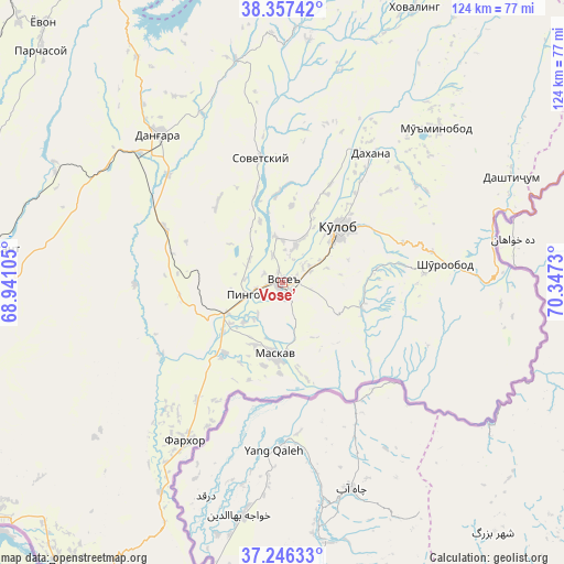
Vose’ GPS coordinates[2]
37° 48' 14.256" North, 69° 38' 39.012" East
| Map corner | latitude | longitude |
|---|---|---|
| Upper-left | 38.35742°, | 68.94105° |
| Center: | 37.80396°, | 69.64417° |
| Lower-right: | 37.24633°, | 70.3473° |
| Map W x H: | 123.5×123.5 km | = 76.7×76.7mi |
| max Lat: | 40.99827° ⇑77.3% North |
| Vose’: | 37.80396° |
| min Lat: | ⇓22.7% South 36.72484° |
| min Long | Vose’ | max Long |
| 67.60931° | 69.64417° | 73.96674° |
| W 59.1%⇐ | ⇒40.9% E |
Elevation
Elevation of Vose’ is 472 m = 1549 ft, and this is 490.5 m = 1609 ft below average elevation for this country.
| Max E: |
3607 m = 11834 ft | 65.9% |
| Avg. | 962.5 m = 3158 ft | |
| Vose’ | 472 m = 1549 ft | |
Min E: |
324 m = 1063 ft | 34.1% |
See also: Tajikistan elevation on elevation.city.
Geographical zone
Vose’ is located in North temperate zone (between Tropic of Cancer and the Arctic Circle). Distance of this Northern Tropic circle is 1597.5 km =992.6 mi to South.| Distance of | km | miles | from Vose’ |
|---|---|---|---|
| North Pole | 5803.7 | 3606.3 | to North |
| Arctic Circle | 3197.8 | 1987 | to North |
| Tropic Cancer | 1597.5 | 992.6 | to South |
| Equator | 4203.4 | 2611.9 | to South |


Nearby cities:
15 places around Vose’: (largest is in red/bold)
• Baljuvon
56.2 km =34.9 mi,  2°
2°
• Bŭstonqal’a
71.6 km =44.5 mi,  273°
273°
• Chubek
21.7 km =13.5 mi,  165°
165°
• Danghara
42 km =26.1 mi,  320°
320°
• Farkhor
40.6 km =25.2 mi,  211°
211°
• Khovaling
66.5 km =41.3 mi,  25°
25°
• Kirov
69 km =42.9 mi, 271°
• Kŭlob
17.4 km =10.8 mi,  45°
45°
• Moskva
16 km =9.9 mi,  184°
184°
• Mŭ’minobod
47.9 km =29.8 mi, 45°
• Norak
70.9 km =44.1 mi,  336°
336°
• Sarband
63.8 km =39.6 mi,  276°
276°
• Shŭrobod
35.8 km =22.2 mi,  83°
83°
• Sovet
27.4 km =17 mi,  349°
349°
• Vakhsh
71.9 km =44.7 mi,  262°
262°
Sources, notices
• [Note1] Compared only with cities in Tajikistan existing in our database
• [Src1] Map data: © OpenStreetMap contributors (CC-BY-SA)
• [Src2] Other city data from geonames.org with taken over terms of usage.
• [Src3] Geographical zone / Annual Mean Temperature by Robert A. Rohde @ Wikipedia
