Kŭlob geodata
Kŭlob (Khatlon) is a seat of a second-order administrative division; located in Tajikistan in Asia/Dushanbe (GMT+5) time zone. With population of 78,786 people, there are 2 cities with bigger population in this country. Compared to other cities in Tajikistan, 70.5% of cities are located further ↑North; 69.3% of cities are located further ←West and 61.4% of cities have higher elevation than Kŭlob. Note1


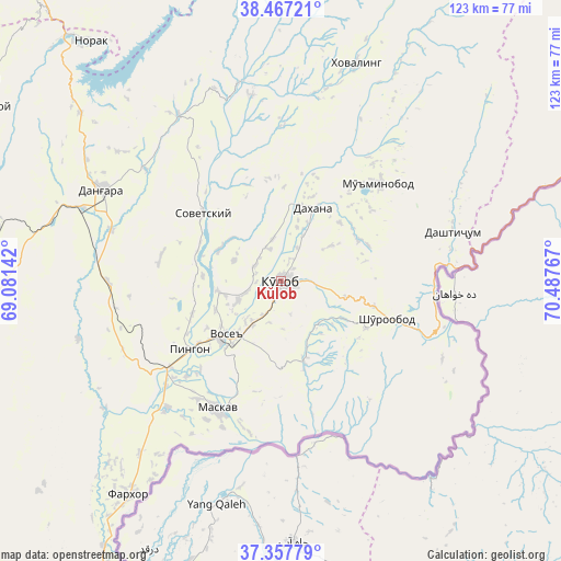
Kŭlob GPS coordinates[2]
37° 54' 52.524" North, 69° 47' 4.344" East
| Map corner | latitude | longitude |
|---|---|---|
| Upper-left | 38.46721°, | 69.08142° |
| Center: | 37.91459°, | 69.78454° |
| Lower-right: | 37.35779°, | 70.48767° |
| Map W x H: | 123.4×123.4 km | = 76.7×76.7mi |
| max Lat: | 40.99827° ⇑70.5% North |
| Kŭlob: | 37.91459° |
| min Lat: | ⇓29.5% South 36.72484° |
| min Long | Kŭlob | max Long |
| 67.60931° | 69.78454° | 73.96674° |
| W 69.3%⇐ | ⇒30.7% E |
Elevation
Elevation of Kŭlob is 609 m = 1998 ft, and this is 353.5 m = 1160 ft below average elevation for this country.
| Max E: |
3607 m = 11834 ft | 61.4% |
| Avg. | 962.5 m = 3158 ft | |
| Kŭlob | 609 m = 1998 ft | |
Min E: |
324 m = 1063 ft | 38.6% |
See also: Kŭlob elevation on elevation.city.
Geographical zone
Kŭlob is located in North temperate zone (between Tropic of Cancer and the Arctic Circle). Distance of this Northern Tropic circle is 1609.8 km =1000.3 mi to South.| Distance of | km | miles | from Kŭlob |
|---|---|---|---|
| North Pole | 5791.4 | 3598.6 | to North |
| Arctic Circle | 3185.5 | 1979.4 | to North |
| Tropic Cancer | 1609.8 | 1000.3 | to South |
| Equator | 4215.7 | 2619.5 | to South |


Nearby cities:
15 places around Kŭlob: (largest is in red/bold)
• Baljuvon
44.8 km =27.8 mi,  347°
347°
• Chubek
34.1 km =21.2 mi,  191°
191°
• Danghara
43.9 km =27.3 mi,  297°
297°
• Farkhor
57.7 km =35.9 mi,  215°
215°
• Fayzobod
81.2 km =50.5 mi,  330°
330°
• Khovaling
50.4 km =31.3 mi,  19°
19°
• Kirov
81.9 km =50.9 mi,  262°
262°
• Moskva
31.4 km =19.5 mi,  205°
205°
• Mŭ’minobod
30.5 km =19 mi,  45°
45°
• Norak
66.4 km =41.3 mi,  322°
322°
• Sarband
75.8 km =47.1 mi,  266°
266°
• Shŭrobod
24.6 km =15.3 mi,  109°
109°
• Sovet
22.6 km =14 mi,  310°
310°
• Vose’
17.4 km =10.8 mi,  225°
225°
• Yovon
79 km =49.1 mi, 304°
Sources, notices
• [Note1] Compared only with cities in Tajikistan existing in our database
• [Src1] Map data: © OpenStreetMap contributors (CC-BY-SA)
• [Src2] Other city data from geonames.org with taken over terms of usage.
• [Src3] Geographical zone / Annual Mean Temperature by Robert A. Rohde @ Wikipedia
