Atamyrat geodata
Atamyrat (Lebap) is a populated place; located in Turkmenistan in Asia/Ashgabat (GMT+5) time zone. With population of 33,242 people, there are 11 cities with bigger population in this country. Compared to other cities in Turkmenistan, 73.3% of cities are located further ↑North; 96.7% of cities are located further ←West and 76.7% of cities have lower elevation than Atamyrat. Note1


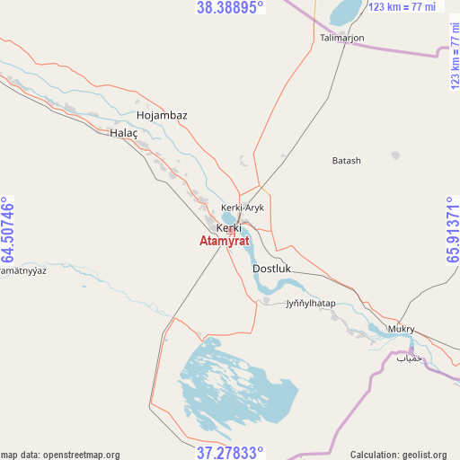
Atamyrat GPS coordinates[2]
37° 50' 8.628" North, 65° 12' 38.088" East
| Map corner | latitude | longitude |
|---|---|---|
| Upper-left | 38.38895°, | 64.50746° |
| Center: | 37.83573°, | 65.21058° |
| Lower-right: | 37.27833°, | 65.91371° |
| Map W x H: | 123.5×123.5 km | = 76.7×76.7mi |
| max Lat: | 42.32773° ⇑73.3% North |
| Atamyrat: | 37.83573° |
| min Lat: | ⇓26.7% South 35.27992° |
| min Long | Atamyrat | max Long |
| 52.95517° | 65.21058° | 66.04656° |
| W 96.7%⇐ | ⇒3.3% E |
Elevation
Elevation of Atamyrat is 244 m = 801 ft, and this is 47.6 m = 156 ft above average elevation for this country.
| Max E: |
649 m = 2129 ft | 23.3% |
| Atamyrat | 244 m 801 ft | |
| Avg. | 196.4 m = 644 ft | |
Min E: |
5 m = 16 ft | 76.7% |
See also: Turkmenistan elevation on elevation.city.
Geographical zone
Atamyrat is located in North temperate zone (between Tropic of Cancer and the Arctic Circle). Distance of this Northern Tropic circle is 1601 km =994.8 mi to South.| Distance of | km | miles | from Atamyrat |
|---|---|---|---|
| North Pole | 5800.1 | 3604 | to North |
| Arctic Circle | 3194.2 | 1984.8 | to North |
| Tropic Cancer | 1601 | 994.8 | to South |
| Equator | 4206.9 | 2614 | to South |


Nearby cities:
10 places around Atamyrat: (largest is in red/bold)
• Bayramaly
268.7 km =167 mi,  264°
264°
• Farap
203.4 km =126.4 mi,  316°
316°
• Gowurdak
73.5 km =45.7 mi,  92°
92°
• Mary
298.5 km =185.5 mi, 264°
• Murgab
287.6 km =178.7 mi, 262°
• Saýat
156.8 km =97.4 mi,  312°
312°
• Serhetabat
382.5 km =237.7 mi,  222°
222°
• Seydi
270.6 km =168.1 mi, 312°
• Türkmenabat
197.8 km =122.9 mi, 314°
• Yolöten
258.2 km =160.4 mi, 256°
Sources, notices
• [Note1] Compared only with cities in Turkmenistan existing in our database
• [Src1] Map data: © OpenStreetMap contributors (CC-BY-SA)
• [Src2] Other city data from geonames.org with taken over terms of usage.
• [Src3] Geographical zone / Annual Mean Temperature by Robert A. Rohde @ Wikipedia
