Mary geodata
Mary is a seat of a first-order administrative division; located in Turkmenistan in Asia/Ashgabat (GMT+5) time zone. With population of 114,680 people, there are 3 cities with bigger population in this country. Compared to other cities in Turkmenistan, 83.3% of cities are located further ↑North; 66.7% of cities are located further ←West and 63.3% of cities have lower elevation than Mary. Note1


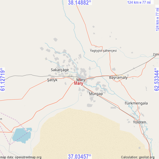
Mary GPS coordinates[2]
37° 35' 37.608" North, 61° 49' 49.116" East
| Map corner | latitude | longitude |
|---|---|---|
| Upper-left | 38.14882°, | 61.12719° |
| Center: | 37.59378°, | 61.83031° |
| Lower-right: | 37.03457°, | 62.53344° |
| Map W x H: | 123.9×123.9 km | = 77×77mi |
| max Lat: | 42.32773° ⇑83.3% North |
| Mary: | 37.59378° |
| min Lat: | ⇓16.7% South 35.27992° |
| min Long | Mary | max Long |
| 52.95517° | 61.83031° | 66.04656° |
| W 66.7%⇐ | ⇒33.3% E |
Elevation
Elevation of Mary is 223 m = 732 ft, and this is 26.6 m = 87 ft above average elevation for this country.
| Max E: |
649 m = 2129 ft | 36.7% |
| Mary | 223 m 732 ft | |
| Avg. | 196.4 m = 644 ft | |
Min E: |
5 m = 16 ft | 63.3% |
See also: Mary elevation on elevation.city.
Geographical zone
Mary is located in North temperate zone (between Tropic of Cancer and the Arctic Circle). Distance of this Northern Tropic circle is 1574.1 km =978.1 mi to South.| Distance of | km | miles | from Mary |
|---|---|---|---|
| North Pole | 5827 | 3620.7 | to North |
| Arctic Circle | 3221.1 | 2001.5 | to North |
| Tropic Cancer | 1574.1 | 978.1 | to South |
| Equator | 4180 | 2597.3 | to South |


Nearby cities:
15 places around Mary: (largest is in red/bold)
• Abadan
323.1 km =200.8 mi,  279°
279°
• Annau
293.2 km =182.2 mi, 276°
• Arçabil
330.7 km =205.5 mi, 276°
• Ashgabat
305.5 km =189.8 mi, 277°
• Atamyrat
298.5 km =185.5 mi,  84°
84°
• Bayramaly
29.8 km =18.5 mi, 84°
• Farap
234.2 km =145.5 mi,  41°
41°
• Kaka
197.4 km =122.7 mi,  262°
262°
• Murgab
16.5 km =10.3 mi,  130°
130°
• Saýat
222.7 km =138.4 mi,  53°
53°
• Serhetabat
261.3 km =162.4 mi,  169°
169°
• Seydi
230.1 km =143 mi,  24°
24°
• Tejen
119.2 km =74.1 mi, 258°
• Türkmenabat
224.3 km =139.4 mi, 42°
• Yolöten
57.1 km =35.5 mi, 125°
Sources, notices
• [Note1] Compared only with cities in Turkmenistan existing in our database
• [Src1] Map data: © OpenStreetMap contributors (CC-BY-SA)
• [Src2] Other city data from geonames.org with taken over terms of usage.
• [Src3] Geographical zone / Annual Mean Temperature by Robert A. Rohde @ Wikipedia
