Türkmenabat geodata
Türkmenabat (Lebap) is a seat of a first-order administrative division; located in Turkmenistan in Asia/Ashgabat (GMT+5) time zone. With population of 234,817 people, there is 1 city with bigger population in this country. Compared to other cities in Turkmenistan, 56.7% of cities are located further ↓South; 86.7% of cities are located further ←West and 50% of cities have lower elevation than Türkmenabat. Note1


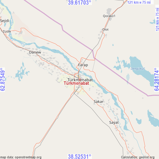
Türkmenabat GPS coordinates[2]
39° 4' 23.808" North, 63° 34' 42.996" East
| Map corner | latitude | longitude |
|---|---|---|
| Upper-left | 39.61703°, | 62.87549° |
| Center: | 39.07328°, | 63.57861° |
| Lower-right: | 38.52531°, | 64.28174° |
| Map W x H: | 121.4×121.4 km | = 75.4×75.4mi |
| max Lat: | 42.32773° ⇑43.3% North |
| Türkmenabat: | 39.07328° |
| min Lat: | ⇓56.7% South 35.27992° |
| min Long | Türkmenabat | max Long |
| 52.95517° | 63.57861° | 66.04656° |
| W 86.7%⇐ | ⇒13.3% E |
Elevation
Elevation of Türkmenabat is 191 m = 627 ft, and this is 5.4 m = 18 ft below average elevation for this country.
| Max E: |
649 m = 2129 ft | 50% |
| Avg. | 196.4 m = 644 ft | |
| Türkmenabat | 191 m = 627 ft | |
Min E: |
5 m = 16 ft | 50% |
See also: Türkmenabat elevation on elevation.city.
Geographical zone
Türkmenabat is located in North temperate zone (between Tropic of Cancer and the Arctic Circle). Distance of this Northern Tropic circle is 1738.6 km =1080.3 mi to South.| Distance of | km | miles | from Türkmenabat |
|---|---|---|---|
| North Pole | 5662.5 | 3518.5 | to North |
| Arctic Circle | 3056.6 | 1899.3 | to North |
| Tropic Cancer | 1738.6 | 1080.3 | to South |
| Equator | 4344.5 | 2699.5 | to South |


Nearby cities:
12 places around Türkmenabat: (largest is in red/bold)
• Atamyrat
197.8 km =122.9 mi,  134°
134°
• Bayramaly
203.3 km =126.3 mi,  217°
217°
• Farap
11.2 km =7 mi,  14°
14°
• Gazojak
299.1 km =185.9 mi,  321°
321°
• Gowurdak
256.6 km =159.4 mi,  123°
123°
• Mary
224.3 km =139.4 mi, 222°
• Murgab
224.5 km =139.5 mi, 218°
• Saýat
41.4 km =25.7 mi,  140°
140°
• Serhetabat
435.7 km =270.7 mi,  194°
194°
• Seydi
73 km =45.4 mi,  308°
308°
• Tejen
327.6 km =203.6 mi,  235°
235°
• Yolöten
224.2 km =139.3 mi,  208°
208°
Sources, notices
• [Note1] Compared only with cities in Turkmenistan existing in our database
• [Src1] Map data: © OpenStreetMap contributors (CC-BY-SA)
• [Src2] Other city data from geonames.org with taken over terms of usage.
• [Src3] Geographical zone / Annual Mean Temperature by Robert A. Rohde @ Wikipedia
