Bayramaly geodata
Bayramaly (Mary) is a populated place; located in Turkmenistan in Asia/Ashgabat (GMT+5) time zone. With population of 75,797 people, there are 5 cities with bigger population in this country. Compared to other cities in Turkmenistan, 80% of cities are located further ↑North; 73.3% of cities are located further ←West and 73.3% of cities have lower elevation than Bayramaly. Note1


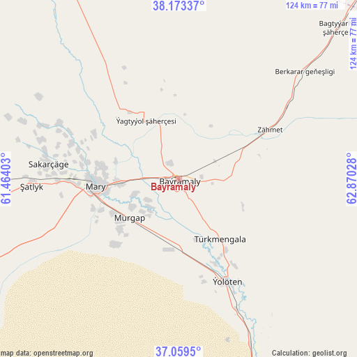
Bayramaly GPS coordinates[2]
37° 37' 6.672" North, 62° 10' 1.74" East
| Map corner | latitude | longitude |
|---|---|---|
| Upper-left | 38.17337°, | 61.46403° |
| Center: | 37.61852°, | 62.16715° |
| Lower-right: | 37.0595°, | 62.87028° |
| Map W x H: | 123.9×123.9 km | = 77×77mi |
| max Lat: | 42.32773° ⇑80% North |
| Bayramaly: | 37.61852° |
| min Lat: | ⇓20% South 35.27992° |
| min Long | Bayramaly | max Long |
| 52.95517° | 62.16715° | 66.04656° |
| W 73.3%⇐ | ⇒26.7% E |
Elevation
Elevation of Bayramaly is 239 m = 784 ft, and this is 42.6 m = 140 ft above average elevation for this country.
| Max E: |
649 m = 2129 ft | 26.7% |
| Bayramaly | 239 m 784 ft | |
| Avg. | 196.4 m = 644 ft | |
Min E: |
5 m = 16 ft | 73.3% |
See also: Bayramaly elevation on elevation.city.
Geographical zone
Bayramaly is located in North temperate zone (between Tropic of Cancer and the Arctic Circle). Distance of this Northern Tropic circle is 1576.9 km =979.8 mi to South.| Distance of | km | miles | from Bayramaly |
|---|---|---|---|
| North Pole | 5824.3 | 3619.1 | to North |
| Arctic Circle | 3218.4 | 1999.8 | to North |
| Tropic Cancer | 1576.9 | 979.8 | to South |
| Equator | 4182.8 | 2599.1 | to South |


Nearby cities:
15 places around Bayramaly: (largest is in red/bold)
• Abadan
351.9 km =218.7 mi,  277°
277°
• Annau
322.4 km =200.3 mi, 275°
• Ashgabat
334.5 km =207.8 mi, 276°
• Atamyrat
268.7 km =167 mi,  84°
84°
• Farap
213.6 km =132.7 mi,  36°
36°
• Gowurdak
341.9 km =212.4 mi,  86°
86°
• Kaka
227.2 km =141.2 mi,  262°
262°
• Mary
29.8 km =18.5 mi, 264°
• Murgab
21.9 km =13.6 mi,  231°
231°
• Saýat
198 km =123 mi,  49°
49°
• Serhetabat
260.5 km =161.9 mi,  176°
176°
• Seydi
217.1 km =134.9 mi,  17°
17°
• Tejen
148.9 km =92.5 mi, 259°
• Türkmenabat
203.3 km =126.3 mi, 37°
• Yolöten
39.4 km =24.5 mi,  154°
154°
Sources, notices
• [Note1] Compared only with cities in Turkmenistan existing in our database
• [Src1] Map data: © OpenStreetMap contributors (CC-BY-SA)
• [Src2] Other city data from geonames.org with taken over terms of usage.
• [Src3] Geographical zone / Annual Mean Temperature by Robert A. Rohde @ Wikipedia
