Yolöten geodata
Yolöten (Mary) is a populated place; located in Turkmenistan in Asia/Ashgabat (GMT+5) time zone. With population of 37,705 people, there are 9 cities with bigger population in this country. Compared to other cities in Turkmenistan, 96.7% of cities are located further ↑North; 80% of cities are located further ←West and 83.3% of cities have lower elevation than Yolöten. Note1


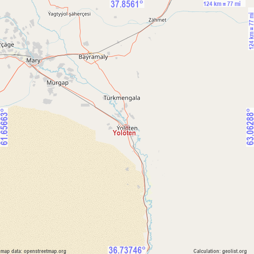
Yolöten GPS coordinates[2]
37° 17' 55.896" North, 62° 21' 35.1" East
| Map corner | latitude | longitude |
|---|---|---|
| Upper-left | 37.8561°, | 61.65663° |
| Center: | 37.29886°, | 62.35975° |
| Lower-right: | 36.73746°, | 63.06288° |
| Map W x H: | 124.4×124.4 km | = 77.3×77.3mi |
| max Lat: | 42.32773° ⇑96.7% North |
| Yolöten: | 37.29886° |
| min Lat: | ⇓3.3% South 35.27992° |
| min Long | Yolöten | max Long |
| 52.95517° | 62.35975° | 66.04656° |
| W 80%⇐ | ⇒20% E |
Elevation
Elevation of Yolöten is 263 m = 863 ft, and this is 66.6 m = 219 ft above average elevation for this country.
| Max E: |
649 m = 2129 ft | 16.7% |
| Yolöten | 263 m 863 ft | |
| Avg. | 196.4 m = 644 ft | |
Min E: |
5 m = 16 ft | 83.3% |
See also: Turkmenistan elevation on elevation.city.
Geographical zone
Yolöten is located in North temperate zone (between Tropic of Cancer and the Arctic Circle). Distance of this Northern Tropic circle is 1541.3 km =957.7 mi to South.| Distance of | km | miles | from Yolöten |
|---|---|---|---|
| North Pole | 5859.8 | 3641.1 | to North |
| Arctic Circle | 3253.9 | 2021.9 | to North |
| Tropic Cancer | 1541.3 | 957.7 | to South |
| Equator | 4147.2 | 2576.9 | to South |


Nearby cities:
13 places around Yolöten: (largest is in red/bold)
• Annau
344.9 km =214.3 mi,  280°
280°
• Atamyrat
258.2 km =160.4 mi,  76°
76°
• Bayramaly
39.4 km =24.5 mi,  334°
334°
• Farap
235.1 km =146.1 mi,  27°
27°
• Gowurdak
329.9 km =205 mi, 80°
• Kaka
242.8 km =150.9 mi,  271°
271°
• Mary
57.1 km =35.5 mi,  305°
305°
• Murgab
40.7 km =25.3 mi,  302°
302°
• Saýat
212.1 km =131.8 mi,  38°
38°
• Serhetabat
224.5 km =139.5 mi,  180°
180°
• Seydi
247.5 km =153.8 mi,  11°
11°
• Tejen
164.2 km =102 mi, 273°
• Türkmenabat
224.2 km =139.3 mi, 28°
Sources, notices
• [Note1] Compared only with cities in Turkmenistan existing in our database
• [Src1] Map data: © OpenStreetMap contributors (CC-BY-SA)
• [Src2] Other city data from geonames.org with taken over terms of usage.
• [Src3] Geographical zone / Annual Mean Temperature by Robert A. Rohde @ Wikipedia
