Sbiba geodata
Sbiba (Al Qaşrayn) is a populated place; located in Tunisia in Africa/Tunis (GMT+1) time zone. With population of 6,291 people, there are 109 cities with bigger population in this country. Compared to other cities in Tunisia, 67.1% of cities are located further ↑North; 81.8% of cities are located further →East and 95.1% of cities have lower elevation than Sbiba. Note1


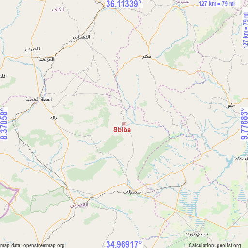
Sbiba GPS coordinates[2]
35° 32' 35.952" North, 9° 4' 25.32" East
| Map corner | latitude | longitude |
|---|---|---|
| Upper-left | 36.11339°, | 8.37058° |
| Center: | 35.54332°, | 9.0737° |
| Lower-right: | 34.96917°, | 9.77683° |
| Map W x H: | 127.2×127.2 km | = 79×79mi |
| max Lat: | 37.27442° ⇑67.1% North |
| Sbiba: | 35.54332° |
| min Lat: | ⇓32.9% South 32.31662° |
| min Long | Sbiba | max Long |
| 7.87765° | 9.0737° | 11.21965° |
| W 18.2%⇐ | ⇒81.8% E |
Elevation
Elevation of Sbiba is 637 m = 2090 ft, and this is 487.6 m = 1600 ft above average elevation for this country.
| Max E: |
999 m = 3278 ft | 4.9% |
| Sbiba | 637 m 2090 ft | |
| Avg. | 149.4 m = 490 ft | |
Min E: |
-6 m = -20 ft | 95.1% |
See also: Tunisia elevation on elevation.city.
Geographical zone
Sbiba is located in North temperate zone (between Tropic of Cancer and the Arctic Circle). Distance of this Northern Tropic circle is 1346.1 km =836.4 mi to South.| Distance of | km | miles | from Sbiba |
|---|---|---|---|
| North Pole | 6055 | 3762.4 | to North |
| Arctic Circle | 3449.1 | 2143.2 | to North |
| Tropic Cancer | 1346.1 | 836.4 | to South |
| Equator | 3952 | 2455.7 | to South |


Nearby cities:
15 places around Sbiba: (largest is in red/bold)
• As Sars
59.5 km =37 mi,  355°
355°
• Bir el Hafey
68.8 km =42.8 mi,  170°
170°
• El Kef
77.6 km =48.2 mi,  334°
334°
• El Ksour
42.8 km =26.6 mi,  336°
336°
• Haffouz
55.4 km =34.4 mi,  79°
79°
• Jilma
43.7 km =27.2 mi,  133°
133°
• Kasserine
47 km =29.2 mi,  207°
207°
• Kesra
39.9 km =24.8 mi,  41°
41°
• Maktar
36.8 km =22.9 mi,  18°
18°
• Menzel Salem
64.2 km =39.9 mi,  302°
302°
• Rohia
12.1 km =7.5 mi,  351°
351°
• Sidi Bouzid
67.4 km =41.9 mi,  146°
146°
• Siliana
65.9 km =40.9 mi, 23°
• Tajerouine
60.9 km =37.8 mi,  309°
309°
• Thala
36.6 km =22.7 mi,  275°
275°
Sources, notices
• [Note1] Compared only with cities in Tunisia existing in our database
• [Src1] Map data: © OpenStreetMap contributors (CC-BY-SA)
• [Src2] Other city data from geonames.org with taken over terms of usage.
• [Src3] Geographical zone / Annual Mean Temperature by Robert A. Rohde @ Wikipedia
