Kesra geodata
Kesra (Silyānah) is a populated place; located in Tunisia in Africa/Tunis (GMT+1) time zone. With population of 2,598 people, there are 139 cities with bigger population in this country. Compared to other cities in Tunisia, 51.7% of cities are located further ↑North; 75.5% of cities are located further →East and 100% of cities have lower elevation than Kesra. Note1


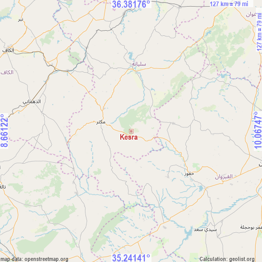
Kesra GPS coordinates[2]
35° 48' 49.068" North, 9° 21' 51.624" East
| Map corner | latitude | longitude |
|---|---|---|
| Upper-left | 36.38176°, | 8.66122° |
| Center: | 35.81363°, | 9.36434° |
| Lower-right: | 35.24141°, | 10.06747° |
| Map W x H: | 126.8×126.8 km | = 78.8×78.8mi |
| max Lat: | 37.27442° ⇑51.7% North |
| Kesra: | 35.81363° |
| min Lat: | ⇓48.3% South 32.31662° |
| min Long | Kesra | max Long |
| 7.87765° | 9.36434° | 11.21965° |
| W 24.5%⇐ | ⇒75.5% E |
Elevation
Elevation of Kesra is 999 m = 3278 ft, and this is 849.6 m = 2787 ft above average elevation for this country.
| Max E: |
999 m = 3278 ft | 0% |
| Kesra | 999 m 3278 ft | |
| Avg. | 149.4 m = 490 ft | |
Min E: |
-6 m = -20 ft | 100% |
See also: Tunisia elevation on elevation.city.
Geographical zone
Kesra is located in North temperate zone (between Tropic of Cancer and the Arctic Circle). Distance of this Northern Tropic circle is 1376.2 km =855.1 mi to South.| Distance of | km | miles | from Kesra |
|---|---|---|---|
| North Pole | 6025 | 3743.8 | to North |
| Arctic Circle | 3419.1 | 2124.5 | to North |
| Tropic Cancer | 1376.2 | 855.1 | to South |
| Equator | 3982.1 | 2474.4 | to South |


Nearby cities:
15 places around Kesra: (largest is in red/bold)
• As Sars
42.5 km =26.4 mi,  313°
313°
• Bou Arada
64.2 km =39.9 mi,  21°
21°
• El Kef
71.6 km =44.5 mi,  304°
304°
• El Ksour
44.2 km =27.5 mi,  281°
281°
• Gafour
56.5 km =35.1 mi,  356°
356°
• Haffouz
34.6 km =21.5 mi,  125°
125°
• Jilma
60.3 km =37.5 mi,  174°
174°
• Kairouan
67.8 km =42.1 mi,  102°
102°
• Le Krib
60.8 km =37.8 mi,  340°
340°
• Maktar
15.6 km =9.7 mi,  288°
288°
• Rohia
33.4 km =20.8 mi,  237°
237°
• Sbiba
39.9 km =24.8 mi,  221°
221°
• Sbikha
60.6 km =37.7 mi,  77°
77°
• Siliana
30.2 km =18.8 mi,  1°
1°
• Thala
68.2 km =42.4 mi,  246°
246°
Sources, notices
• [Note1] Compared only with cities in Tunisia existing in our database
• [Src1] Map data: © OpenStreetMap contributors (CC-BY-SA)
• [Src2] Other city data from geonames.org with taken over terms of usage.
• [Src3] Geographical zone / Annual Mean Temperature by Robert A. Rohde @ Wikipedia
