Thala geodata
Thala (Al Qaşrayn) is a populated place; located in Tunisia in Africa/Tunis (GMT+1) time zone. With population of 16,068 people, there are 67 cities with bigger population in this country. Compared to other cities in Tunisia, 65.7% of cities are located further ↑North; 92.3% of cities are located further →East and 99.3% of cities have lower elevation than Thala. Note1


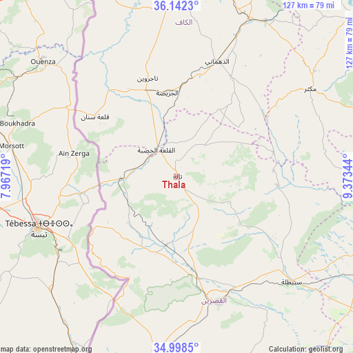
Thala GPS coordinates[2]
35° 34' 20.784" North, 8° 40' 13.116" East
| Map corner | latitude | longitude |
|---|---|---|
| Upper-left | 36.1423°, | 7.96719° |
| Center: | 35.57244°, | 8.67031° |
| Lower-right: | 34.9985°, | 9.37344° |
| Map W x H: | 127.2×127.2 km | = 79×79mi |
| max Lat: | 37.27442° ⇑65.7% North |
| Thala: | 35.57244° |
| min Lat: | ⇓34.3% South 32.31662° |
| min Long | Thala | max Long |
| 7.87765° | 8.67031° | 11.21965° |
| W 7.7%⇐ | ⇒92.3% E |
Elevation
Elevation of Thala is 962 m = 3156 ft, and this is 812.6 m = 2666 ft above average elevation for this country.
| Max E: |
999 m = 3278 ft | 0.7% |
| Thala | 962 m 3156 ft | |
| Avg. | 149.4 m = 490 ft | |
Min E: |
-6 m = -20 ft | 99.3% |
See also: Tunisia elevation on elevation.city.
Geographical zone
Thala is located in North temperate zone (between Tropic of Cancer and the Arctic Circle). Distance of this Northern Tropic circle is 1349.4 km =838.5 mi to South.| Distance of | km | miles | from Thala |
|---|---|---|---|
| North Pole | 6051.8 | 3760.4 | to North |
| Arctic Circle | 3445.9 | 2141.2 | to North |
| Tropic Cancer | 1349.4 | 838.5 | to South |
| Equator | 3955.3 | 2457.7 | to South |


Nearby cities:
15 places around Thala: (largest is in red/bold)
• As Sars
64.3 km =40 mi,  29°
29°
• Bir el Hafey
85.6 km =53.2 mi,  146°
146°
• El Kef
67 km =41.6 mi,  2°
2°
• El Ksour
40.9 km =25.4 mi, 28°
• Jilma
76 km =47.2 mi,  115°
115°
• Kasserine
47.5 km =29.5 mi,  161°
161°
• Kesra
68.2 km =42.4 mi,  66°
66°
• Maktar
57.5 km =35.7 mi,  56°
56°
• Menzel Salem
36.1 km =22.4 mi,  331°
331°
• Nibbar
80.7 km =50.1 mi,  6°
6°
• Rohia
35.7 km =22.2 mi,  75°
75°
• Sakiet Sidi Youssef
77.7 km =48.3 mi,  338°
338°
• Sbiba
36.6 km =22.7 mi,  95°
95°
• Siliana
85.1 km =52.9 mi,  47°
47°
• Tajerouine
37.1 km =23.1 mi, 343°
Sources, notices
• [Note1] Compared only with cities in Tunisia existing in our database
• [Src1] Map data: © OpenStreetMap contributors (CC-BY-SA)
• [Src2] Other city data from geonames.org with taken over terms of usage.
• [Src3] Geographical zone / Annual Mean Temperature by Robert A. Rohde @ Wikipedia
