Maktar geodata
Maktar (Silyānah) is a populated place; located in Tunisia in Africa/Tunis (GMT+1) time zone. With population of 14,500 people, there are 72 cities with bigger population in this country. Compared to other cities in Tunisia, 50.3% of cities are located further ↓South; 79% of cities are located further →East and 98.6% of cities have lower elevation than Maktar. Note1


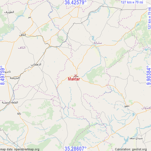
Maktar GPS coordinates[2]
35° 51' 28.728" North, 9° 12' 2.592" East
| Map corner | latitude | longitude |
|---|---|---|
| Upper-left | 36.42579°, | 8.49759° |
| Center: | 35.85798°, | 9.20072° |
| Lower-right: | 35.28607°, | 9.90384° |
| Map W x H: | 126.7×126.7 km | = 78.7×78.7mi |
| max Lat: | 37.27442° ⇑49.7% North |
| Maktar: | 35.85798° |
| min Lat: | ⇓50.3% South 32.31662° |
| min Long | Maktar | max Long |
| 7.87765° | 9.20072° | 11.21965° |
| W 21%⇐ | ⇒79% E |
Elevation
Elevation of Maktar is 924 m = 3031 ft, and this is 774.6 m = 2541 ft above average elevation for this country.
| Max E: |
999 m = 3278 ft | 1.4% |
| Maktar | 924 m 3031 ft | |
| Avg. | 149.4 m = 490 ft | |
Min E: |
-6 m = -20 ft | 98.6% |
See also: Tunisia elevation on elevation.city.
Geographical zone
Maktar is located in North temperate zone (between Tropic of Cancer and the Arctic Circle). Distance of this Northern Tropic circle is 1381.1 km =858.2 mi to South.| Distance of | km | miles | from Maktar |
|---|---|---|---|
| North Pole | 6020 | 3740.7 | to North |
| Arctic Circle | 3414.1 | 2121.4 | to North |
| Tropic Cancer | 1381.1 | 858.2 | to South |
| Equator | 3987 | 2477.4 | to South |


Nearby cities:
15 places around Maktar: (largest is in red/bold)
• As Sars
29.2 km =18.1 mi,  326°
326°
• El Kef
56.8 km =35.3 mi,  308°
308°
• El Ksour
28.8 km =17.9 mi,  278°
278°
• Gafour
52.6 km =32.7 mi,  12°
12°
• Haffouz
49.7 km =30.9 mi,  120°
120°
• Kesra
15.6 km =9.7 mi,  108°
108°
• Le Krib
52.6 km =32.7 mi,  353°
353°
• Menzel Salem
65.3 km =40.6 mi,  269°
269°
• Nibbar
62.2 km =38.6 mi,  321°
321°
• Rohia
26.6 km =16.5 mi,  210°
210°
• Sbiba
36.8 km =22.9 mi,  198°
198°
• Siliana
29.5 km =18.3 mi,  31°
31°
• Tabursuq
66.7 km =41.4 mi,  3°
3°
• Tajerouine
58.5 km =36.4 mi, 273°
• Thala
57.5 km =35.7 mi,  236°
236°
Sources, notices
• [Note1] Compared only with cities in Tunisia existing in our database
• [Src1] Map data: © OpenStreetMap contributors (CC-BY-SA)
• [Src2] Other city data from geonames.org with taken over terms of usage.
• [Src3] Geographical zone / Annual Mean Temperature by Robert A. Rohde @ Wikipedia
