Medjez el Bab geodata
Medjez el Bab (Bājah) is a populated place; located in Tunisia in Africa/Tunis (GMT+1) time zone. With population of 20,118 people, there are 55 cities with bigger population in this country. Compared to other cities in Tunisia, 73.4% of cities are located further ↓South; 72% of cities are located further →East and 51.7% of cities have lower elevation than Medjez el Bab. Note1


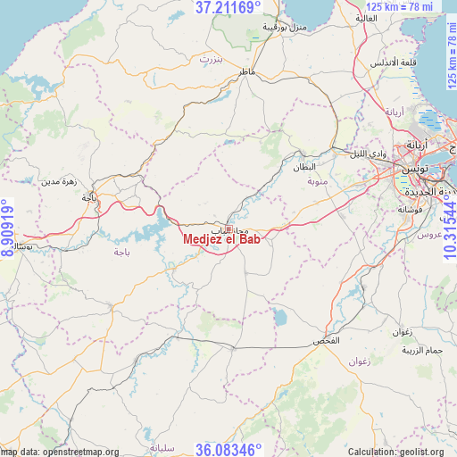
Medjez el Bab GPS coordinates[2]
36° 38' 58.704" North, 9° 36' 44.316" East
| Map corner | latitude | longitude |
|---|---|---|
| Upper-left | 37.21169°, | 8.90919° |
| Center: | 36.64964°, | 9.61231° |
| Lower-right: | 36.08346°, | 10.31544° |
| Map W x H: | 125.4×125.4 km | = 77.9×77.9mi |
| max Lat: | 37.27442° ⇑26.6% North |
| Medjez el Bab: | 36.64964° |
| min Lat: | ⇓73.4% South 32.31662° |
| min Long | Medjez el Bab | max Long |
| 7.87765° | 9.61231° | 11.21965° |
| W 28%⇐ | ⇒72% E |
Elevation
Elevation of Medjez el Bab is 51 m = 167 ft, and this is 98.4 m = 323 ft below average elevation for this country.
| Max E: |
999 m = 3278 ft | 48.3% |
| Avg. | 149.4 m = 490 ft | |
| Medjez el Bab | 51 m = 167 ft | |
Min E: |
-6 m = -20 ft | 51.7% |
See also: Tunisia elevation on elevation.city.
Geographical zone
Medjez el Bab is located in North temperate zone (between Tropic of Cancer and the Arctic Circle). Distance of this Northern Tropic circle is 1469.1 km =912.9 mi to South.| Distance of | km | miles | from Medjez el Bab |
|---|---|---|---|
| North Pole | 5932 | 3686 | to North |
| Arctic Circle | 3326.1 | 2066.7 | to North |
| Tropic Cancer | 1469.1 | 912.9 | to South |
| Equator | 4075.1 | 2532.1 | to South |


Nearby cities:
15 places around Medjez el Bab: (largest is in red/bold)
• Ben Arous
55.6 km =34.5 mi,  77°
77°
• Bou Arada
33 km =20.5 mi,  178°
178°
• Béja
39.3 km =24.4 mi,  282°
282°
• El Battan
26.8 km =16.7 mi,  50°
50°
• El Fahs
40.4 km =25.1 mi,  139°
139°
• Gafour
44.8 km =27.8 mi,  215°
215°
• Goubellat
12.8 km =8 mi,  159°
159°
• La Mohammedia
48.6 km =30.2 mi,  86°
86°
• Manouba
46.6 km =29 mi,  67°
67°
• Mateur
43.7 km =27.2 mi,  6°
6°
• Oued Lill
43.3 km =26.9 mi,  61°
61°
• Tabursuq
39 km =24.2 mi,  236°
236°
• Testour
18.6 km =11.6 mi,  234°
234°
• Tunis
52.8 km =32.8 mi, 69°
• Zaghouan
54.8 km =34.1 mi,  120°
120°
Sources, notices
• [Note1] Compared only with cities in Tunisia existing in our database
• [Src1] Map data: © OpenStreetMap contributors (CC-BY-SA)
• [Src2] Other city data from geonames.org with taken over terms of usage.
• [Src3] Geographical zone / Annual Mean Temperature by Robert A. Rohde @ Wikipedia
