Béja geodata
Béja (Bājah) is a seat of a first-order administrative division; located in Tunisia in Africa/Tunis (GMT+1) time zone. With population of 57,233 people, there are 22 cities with bigger population in this country. Compared to other cities in Tunisia, 78.3% of cities are located further ↓South; 80.4% of cities are located further →East and 79.7% of cities have lower elevation than Béja. Note1


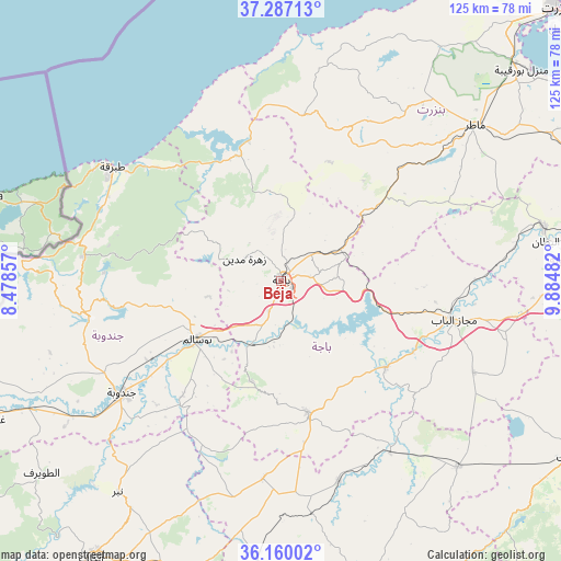
Béja GPS coordinates[2]
36° 43' 32.304" North, 9° 10' 54.084" East
| Map corner | latitude | longitude |
|---|---|---|
| Upper-left | 37.28713°, | 8.47857° |
| Center: | 36.72564°, | 9.18169° |
| Lower-right: | 36.16002°, | 9.88482° |
| Map W x H: | 125.3×125.3 km | = 77.9×77.9mi |
| max Lat: | 37.27442° ⇑21.7% North |
| Béja: | 36.72564° |
| min Lat: | ⇓78.3% South 32.31662° |
| min Long | Béja | max Long |
| 7.87765° | 9.18169° | 11.21965° |
| W 19.6%⇐ | ⇒80.4% E |
Elevation
Elevation of Béja is 248 m = 814 ft, and this is 98.6 m = 323 ft above average elevation for this country.
| Max E: |
999 m = 3278 ft | 20.3% |
| Béja | 248 m 814 ft | |
| Avg. | 149.4 m = 490 ft | |
Min E: |
-6 m = -20 ft | 79.7% |
See also: Béja elevation on elevation.city.
Geographical zone
Béja is located in North temperate zone (between Tropic of Cancer and the Arctic Circle). Distance of this Northern Tropic circle is 1477.6 km =918.1 mi to South.| Distance of | km | miles | from Béja |
|---|---|---|---|
| North Pole | 5923.6 | 3680.8 | to North |
| Arctic Circle | 3317.7 | 2061.5 | to North |
| Tropic Cancer | 1477.6 | 918.1 | to South |
| Equator | 4083.5 | 2537.4 | to South |


Nearby cities:
15 places around Béja: (largest is in red/bold)
• Bou Arada
57.2 km =35.5 mi,  136°
136°
• El Battan
59.7 km =37.1 mi,  81°
81°
• Fernana
44 km =27.3 mi,  259°
259°
• Gafour
46.8 km =29.1 mi,  164°
164°
• Goubellat
47.6 km =29.6 mi,  115°
115°
• Jendouba
43.7 km =27.2 mi,  235°
235°
• Le Krib
44.4 km =27.6 mi,  185°
185°
• Mateur
55.5 km =34.5 mi,  50°
50°
• Medjez el Bab
39.3 km =24.4 mi,  102°
102°
• Nibbar
60.7 km =37.7 mi,  217°
217°
• Oued Meliz
63.3 km =39.3 mi, 243°
• Sejenane
37.2 km =23.1 mi,  7°
7°
• Tabarka
45.5 km =28.3 mi,  304°
304°
• Tabursuq
30.5 km =19 mi,  168°
168°
• Testour
30.3 km =18.8 mi,  129°
129°
Sources, notices
• [Note1] Compared only with cities in Tunisia existing in our database
• [Src1] Map data: © OpenStreetMap contributors (CC-BY-SA)
• [Src2] Other city data from geonames.org with taken over terms of usage.
• [Src3] Geographical zone / Annual Mean Temperature by Robert A. Rohde @ Wikipedia
