Tabursuq geodata
Tabursuq (Bājah) is a populated place; located in Tunisia in Africa/Tunis (GMT+1) time zone. With population of 12,727 people, there are 79 cities with bigger population in this country. Compared to other cities in Tunisia, 65.7% of cities are located further ↓South; 77.6% of cities are located further →East and 87.4% of cities have lower elevation than Tabursuq. Note1


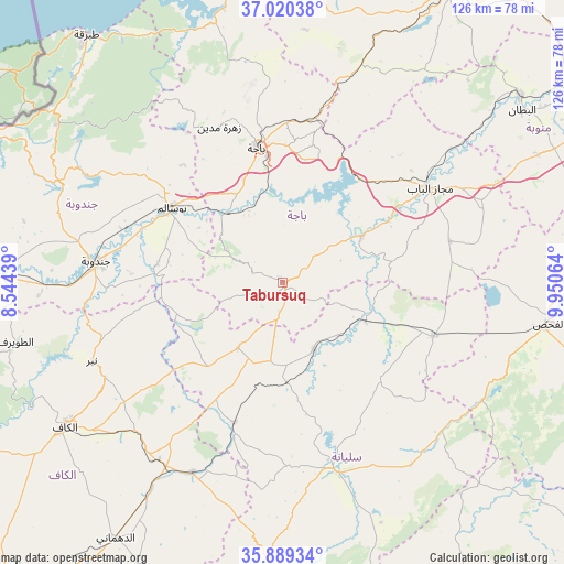
Tabursuq GPS coordinates[2]
36° 27' 24.912" North, 9° 14' 51.036" East
| Map corner | latitude | longitude |
|---|---|---|
| Upper-left | 37.02038°, | 8.54439° |
| Center: | 36.45692°, | 9.24751° |
| Lower-right: | 35.88934°, | 9.95064° |
| Map W x H: | 125.8×125.8 km | = 78.2×78.2mi |
| max Lat: | 37.27442° ⇑34.3% North |
| Tabursuq: | 36.45692° |
| min Lat: | ⇓65.7% South 32.31662° |
| min Long | Tabursuq | max Long |
| 7.87765° | 9.24751° | 11.21965° |
| W 22.4%⇐ | ⇒77.6% E |
Elevation
Elevation of Tabursuq is 426 m = 1398 ft, and this is 276.6 m = 907 ft above average elevation for this country.
| Max E: |
999 m = 3278 ft | 12.6% |
| Tabursuq | 426 m 1398 ft | |
| Avg. | 149.4 m = 490 ft | |
Min E: |
-6 m = -20 ft | 87.4% |
See also: Tunisia elevation on elevation.city.
Geographical zone
Tabursuq is located in North temperate zone (between Tropic of Cancer and the Arctic Circle). Distance of this Northern Tropic circle is 1447.7 km =899.6 mi to South.| Distance of | km | miles | from Tabursuq |
|---|---|---|---|
| North Pole | 5953.4 | 3699.3 | to North |
| Arctic Circle | 3347.5 | 2080 | to North |
| Tropic Cancer | 1447.7 | 899.6 | to South |
| Equator | 4053.6 | 2518.8 | to South |


Nearby cities:
15 places around Tabursuq: (largest is in red/bold)
• As Sars
46.9 km =29.1 mi,  205°
205°
• Bou Arada
35.4 km =22 mi,  109°
109°
• Béja
30.5 km =19 mi,  348°
348°
• El Fahs
59.7 km =37.1 mi,  98°
98°
• El Kef
57.9 km =36 mi,  237°
237°
• Fernana
54 km =33.6 mi,  294°
294°
• Gafour
16.7 km =10.4 mi,  155°
155°
• Goubellat
38.3 km =23.8 mi,  75°
75°
• Jendouba
42.1 km =26.2 mi,  276°
276°
• Le Krib
17.5 km =10.9 mi, 214°
• Medjez el Bab
39 km =24.2 mi,  56°
56°
• Nibbar
46.7 km =29 mi,  247°
247°
• Oued Meliz
62.4 km =38.8 mi,  271°
271°
• Siliana
42.8 km =26.6 mi,  165°
165°
• Testour
20.4 km =12.7 mi, 59°
Sources, notices
• [Note1] Compared only with cities in Tunisia existing in our database
• [Src1] Map data: © OpenStreetMap contributors (CC-BY-SA)
• [Src2] Other city data from geonames.org with taken over terms of usage.
• [Src3] Geographical zone / Annual Mean Temperature by Robert A. Rohde @ Wikipedia
