Skhira geodata
Skhira (Şafāqis) is a populated place; located in Tunisia in Africa/Tunis (GMT+1) time zone. With population of 9,211 people, there are 89 cities with bigger population in this country. Compared to other cities in Tunisia, 86% of cities are located further ↑North; 56.6% of cities are located further →East and 59.4% of cities have higher elevation than Skhira. Note1


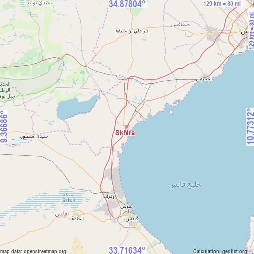
Skhira GPS coordinates[2]
34° 17' 57.12" North, 10° 4' 11.964" East
| Map corner | latitude | longitude |
|---|---|---|
| Upper-left | 34.87804°, | 9.36686° |
| Center: | 34.2992°, | 10.06999° |
| Lower-right: | 33.71634°, | 10.77312° |
| Map W x H: | 129.2×129.2 km | = 80.3×80.3mi |
| max Lat: | 37.27442° ⇑86% North |
| Skhira: | 34.2992° |
| min Lat: | ⇓14% South 32.31662° |
| min Long | Skhira | max Long |
| 7.87765° | 10.06999° | 11.21965° |
| W 43.4%⇐ | ⇒56.6% E |
Elevation
Elevation of Skhira is 33 m = 108 ft, and this is 116.4 m = 382 ft below average elevation for this country.
| Max E: |
999 m = 3278 ft | 59.4% |
| Avg. | 149.4 m = 490 ft | |
| Skhira | 33 m = 108 ft | |
Min E: |
-6 m = -20 ft | 40.6% |
See also: Tunisia elevation on elevation.city.
Geographical zone
Skhira is located in North temperate zone (between Tropic of Cancer and the Arctic Circle). Distance of this Northern Tropic circle is 1207.8 km =750.5 mi to South.| Distance of | km | miles | from Skhira |
|---|---|---|---|
| North Pole | 6193.3 | 3848.3 | to North |
| Arctic Circle | 3587.5 | 2229.2 | to North |
| Tropic Cancer | 1207.8 | 750.5 | to South |
| Equator | 3813.7 | 2369.7 | to South |


Nearby cities:
15 places around Skhira: (largest is in red/bold)
• As Sanad
76.2 km =47.3 mi,  283°
283°
• Bir Ali Ben Khalifa
48.6 km =30.2 mi,  2°
2°
• Bir el Hafey
106.7 km =66.3 mi,  311°
311°
• Bou Attouche
51.6 km =32.1 mi,  210°
210°
• El Hamma
51.9 km =32.2 mi, 209°
• Er Regueb
67.5 km =41.9 mi,  337°
337°
• Erriadh
89.7 km =55.7 mi,  126°
126°
• Gabès
46.5 km =28.9 mi,  176°
176°
• Gremda
82.4 km =51.2 mi,  52°
52°
• Houmt El Souk
86.5 km =53.7 mi,  122°
122°
• Matmata
84.4 km =52.4 mi,  186°
186°
• Mezzouna
37.4 km =23.2 mi,  325°
325°
• Midoun
101 km =62.8 mi, 122°
• Sfax
80 km =49.7 mi, 52°
• Sidi Bouzid
98.1 km =61 mi, 326°
Sources, notices
• [Note1] Compared only with cities in Tunisia existing in our database
• [Src1] Map data: © OpenStreetMap contributors (CC-BY-SA)
• [Src2] Other city data from geonames.org with taken over terms of usage.
• [Src3] Geographical zone / Annual Mean Temperature by Robert A. Rohde @ Wikipedia
