Gabès geodata
Gabès (Qābis) is a seat of a first-order administrative division; located in Tunisia in Africa/Tunis (GMT+1) time zone. With population of 110,075 people, there are 5 cities with bigger population in this country. Compared to other cities in Tunisia, 89.5% of cities are located further ↑North; 53.8% of cities are located further →East and 88.1% of cities have higher elevation than Gabès. Note1


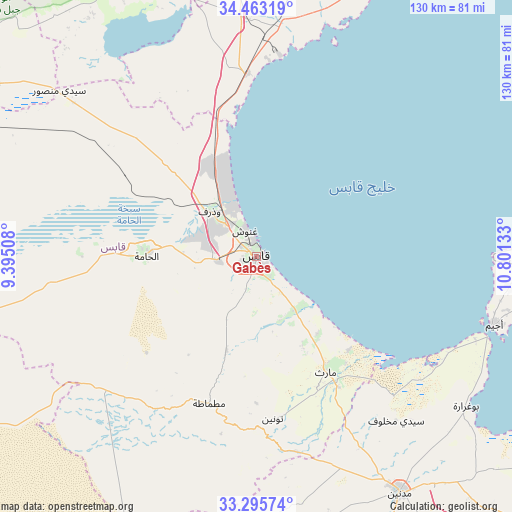
Gabès GPS coordinates[2]
33° 52' 53.256" North, 10° 5' 53.52" East
| Map corner | latitude | longitude |
|---|---|---|
| Upper-left | 34.46319°, | 9.39508° |
| Center: | 33.88146°, | 10.0982° |
| Lower-right: | 33.29574°, | 10.80133° |
| Map W x H: | 129.8×129.8 km | = 80.7×80.7mi |
| max Lat: | 37.27442° ⇑89.5% North |
| Gabès: | 33.88146° |
| min Lat: | ⇓10.5% South 32.31662° |
| min Long | Gabès | max Long |
| 7.87765° | 10.0982° | 11.21965° |
| W 46.2%⇐ | ⇒53.8% E |
Elevation
Elevation of Gabès is 9 m = 30 ft, and this is 140.4 m = 461 ft below average elevation for this country.
| Max E: |
999 m = 3278 ft | 88.1% |
| Avg. | 149.4 m = 490 ft | |
| Gabès | 9 m = 30 ft | |
Min E: |
-6 m = -20 ft | 11.9% |
See also: Gabès elevation on elevation.city.
Geographical zone
Gabès is located in North temperate zone (between Tropic of Cancer and the Arctic Circle). Distance of this Northern Tropic circle is 1161.3 km =721.6 mi to South.| Distance of | km | miles | from Gabès |
|---|---|---|---|
| North Pole | 6239.8 | 3877.2 | to North |
| Arctic Circle | 3633.9 | 2258 | to North |
| Tropic Cancer | 1161.3 | 721.6 | to South |
| Equator | 3767.3 | 2340.9 | to South |


Nearby cities:
15 places around Gabès: (largest is in red/bold)
• As Sanad
100.3 km =62.3 mi,  310°
310°
• Beni Kheddache
70.5 km =43.8 mi,  172°
172°
• Bir Ali Ben Khalifa
95 km =59 mi,  359°
359°
• Bou Attouche
29 km =18 mi,  273°
273°
• El Hamma
27.9 km =17.3 mi, 272°
• Erriadh
70.1 km =43.6 mi,  95°
95°
• Houmt El Souk
70.1 km =43.6 mi,  90°
90°
• Jemna
105.7 km =65.7 mi,  251°
251°
• Kebili
106.2 km =66 mi,  259°
259°
• Matmata
39.3 km =24.4 mi,  197°
197°
• Medenine
69.6 km =43.2 mi,  147°
147°
• Mezzouna
80.9 km =50.3 mi,  343°
343°
• Midoun
83 km =51.6 mi, 95°
• Skhira
46.5 km =28.9 mi, 356°
• Zarzis
102.8 km =63.9 mi,  114°
114°
Sources, notices
• [Note1] Compared only with cities in Tunisia existing in our database
• [Src1] Map data: © OpenStreetMap contributors (CC-BY-SA)
• [Src2] Other city data from geonames.org with taken over terms of usage.
• [Src3] Geographical zone / Annual Mean Temperature by Robert A. Rohde @ Wikipedia
