Matmata geodata
Matmata (Qābis) is a populated place; located in Tunisia in Africa/Tunis (GMT+1) time zone. With population of 2,406 people, there are 140 cities with bigger population in this country. Compared to other cities in Tunisia, 94.4% of cities are located further ↑North; 60.8% of cities are located further →East and 86% of cities have lower elevation than Matmata. Note1


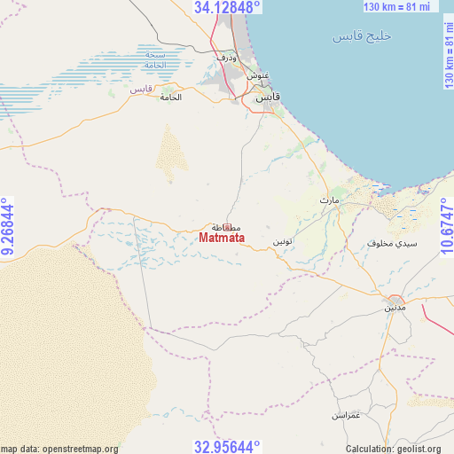
Matmata GPS coordinates[2]
33° 32' 40.02" North, 9° 58' 17.652" East
| Map corner | latitude | longitude |
|---|---|---|
| Upper-left | 34.12848°, | 9.26844° |
| Center: | 33.54445°, | 9.97157° |
| Lower-right: | 32.95644°, | 10.6747° |
| Map W x H: | 130.3×130.3 km | = 81×81mi |
| max Lat: | 37.27442° ⇑94.4% North |
| Matmata: | 33.54445° |
| min Lat: | ⇓5.6% South 32.31662° |
| min Long | Matmata | max Long |
| 7.87765° | 9.97157° | 11.21965° |
| W 39.2%⇐ | ⇒60.8% E |
Elevation
Elevation of Matmata is 378 m = 1240 ft, and this is 228.6 m = 750 ft above average elevation for this country.
| Max E: |
999 m = 3278 ft | 14% |
| Matmata | 378 m 1240 ft | |
| Avg. | 149.4 m = 490 ft | |
Min E: |
-6 m = -20 ft | 86% |
See also: Tunisia elevation on elevation.city.
Geographical zone
Matmata is located in North temperate zone (between Tropic of Cancer and the Arctic Circle). Distance of this Northern Tropic circle is 1123.9 km =698.4 mi to South.| Distance of | km | miles | from Matmata |
|---|---|---|---|
| North Pole | 6277.3 | 3900.5 | to North |
| Arctic Circle | 3671.4 | 2281.3 | to North |
| Tropic Cancer | 1123.9 | 698.4 | to South |
| Equator | 3729.8 | 2317.6 | to South |


Nearby cities:
15 places around Matmata: (largest is in red/bold)
• Beni Kheddache
38.7 km =24 mi,  146°
146°
• Bou Attouche
43.1 km =26.8 mi,  336°
336°
• Douz
88.6 km =55.1 mi,  264°
264°
• El Golaa
89.7 km =55.7 mi,  265°
265°
• El Hamma
41.9 km =26 mi, 337°
• Erriadh
87.2 km =54.2 mi,  69°
69°
• Gabès
39.3 km =24.4 mi,  17°
17°
• Houmt El Souk
89.8 km =55.8 mi, 65°
• Jemna
88.7 km =55.1 mi, 272°
• Kebili
94.5 km =58.7 mi,  280°
280°
• Medenine
53.8 km =33.4 mi,  113°
113°
• Midoun
98.9 km =61.5 mi, 72°
• Skhira
84.4 km =52.4 mi,  6°
6°
• Tataouine
81.7 km =50.8 mi, 146°
• Zarzis
105.8 km =65.7 mi,  92°
92°
Sources, notices
• [Note1] Compared only with cities in Tunisia existing in our database
• [Src1] Map data: © OpenStreetMap contributors (CC-BY-SA)
• [Src2] Other city data from geonames.org with taken over terms of usage.
• [Src3] Geographical zone / Annual Mean Temperature by Robert A. Rohde @ Wikipedia
