Erriadh geodata
Erriadh (Madanīn) is a populated place; located in Tunisia in Africa/Tunis (GMT+1) time zone. With population of 14,426 people, there are 73 cities with bigger population in this country. Compared to other cities in Tunisia, 91.6% of cities are located further ↑North; 84.6% of cities are located further ←West and 82.5% of cities have higher elevation than Erriadh. Note1


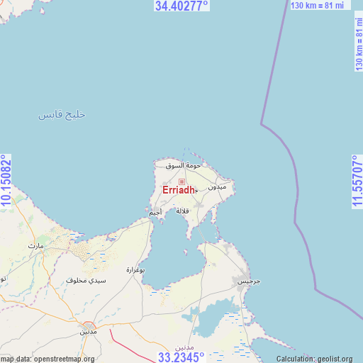
Erriadh GPS coordinates[2]
33° 49' 14.268" North, 10° 51' 14.184" East
| Map corner | latitude | longitude |
|---|---|---|
| Upper-left | 34.40277°, | 10.15082° |
| Center: | 33.82063°, | 10.85394° |
| Lower-right: | 33.2345°, | 11.55707° |
| Map W x H: | 129.9×129.9 km | = 80.7×80.7mi |
| max Lat: | 37.27442° ⇑91.6% North |
| Erriadh: | 33.82063° |
| min Lat: | ⇓8.4% South 32.31662° |
| min Long | Erriadh | max Long |
| 7.87765° | 10.85394° | 11.21965° |
| W 84.6%⇐ | ⇒15.4% E |
Elevation
Elevation of Erriadh is 11 m = 36 ft, and this is 138.4 m = 454 ft below average elevation for this country.
| Max E: |
999 m = 3278 ft | 82.5% |
| Avg. | 149.4 m = 490 ft | |
| Erriadh | 11 m = 36 ft | |
Min E: |
-6 m = -20 ft | 17.5% |
See also: Tunisia elevation on elevation.city.
Geographical zone
Erriadh is located in North temperate zone (between Tropic of Cancer and the Arctic Circle). Distance of this Northern Tropic circle is 1154.6 km =717.4 mi to South.| Distance of | km | miles | from Erriadh |
|---|---|---|---|
| North Pole | 6246.6 | 3881.5 | to North |
| Arctic Circle | 3640.7 | 2262.2 | to North |
| Tropic Cancer | 1154.6 | 717.4 | to South |
| Equator | 3760.5 | 2336.7 | to South |


Nearby cities:
15 places around Erriadh: (largest is in red/bold)
• Ben Gardane
83.2 km =51.7 mi,  155°
155°
• Beni Kheddache
87.6 km =54.4 mi,  223°
223°
• Bir Ali Ben Khalifa
123.5 km =76.7 mi,  325°
325°
• Bou Attouche
99.1 km =61.6 mi,  275°
275°
• El Hamma
98 km =60.9 mi,  274°
274°
• Gabès
70.1 km =43.6 mi, 275°
• Gremda
103.5 km =64.3 mi,  356°
356°
• Houmt El Souk
6.1 km =3.8 mi,  3°
3°
• Matmata
87.2 km =54.2 mi,  249°
249°
• Medenine
61 km =37.9 mi,  211°
211°
• Midoun
12.9 km =8 mi,  96°
96°
• Sfax
102.6 km =63.8 mi, 355°
• Skhira
89.7 km =55.7 mi,  306°
306°
• Tataouine
105.9 km =65.8 mi,  200°
200°
• Zarzis
42.6 km =26.5 mi,  145°
145°
Sources, notices
• [Note1] Compared only with cities in Tunisia existing in our database
• [Src1] Map data: © OpenStreetMap contributors (CC-BY-SA)
• [Src2] Other city data from geonames.org with taken over terms of usage.
• [Src3] Geographical zone / Annual Mean Temperature by Robert A. Rohde @ Wikipedia
