Marmaris geodata
Marmaris (Muğla) is a seat of a second-order administrative division; located in Turkey in Europe/Istanbul (GMT+3) time zone. With population of 33,731 people, there are 231 cities with bigger population in this country. Compared to other cities in Turkey, 91.7% of cities are located further ↑North; 88.3% of cities are located further →East and 98.6% of cities have higher elevation than Marmaris. Note1


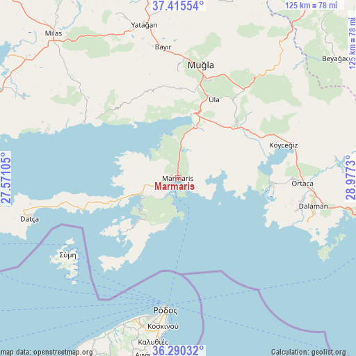
Marmaris GPS coordinates[2]
36° 51' 18" North, 28° 16' 27.012" East
| Map corner | latitude | longitude |
|---|---|---|
| Upper-left | 37.41554°, | 27.57105° |
| Center: | 36.855°, | 28.27417° |
| Lower-right: | 36.29032°, | 28.9773° |
| Map W x H: | 125.1×125.1 km | = 77.7×77.7mi |
| max Lat: | 42.02683° ⇑91.7% North |
| Marmaris: | 36.855° |
| min Lat: | ⇓8.3% South 35.9025° |
| min Long | Marmaris | max Long |
| 25.90902° | 28.27417° | 44.60099° |
| W 11.7%⇐ | ⇒88.3% E |
Elevation
Elevation of Marmaris is 8 m = 26 ft, and this is 709.4 m = 2327 ft below average elevation for this country.
| Max E: |
2682 m = 8799 ft | 98.6% |
| Avg. | 717.4 m = 2354 ft | |
| Marmaris | 8 m = 26 ft | |
Min E: |
0 m = 0 ft | 1.4% |
See also: Turkey elevation on elevation.city.
Geographical zone
Marmaris is located in North temperate zone (between Tropic of Cancer and the Arctic Circle). Distance of this Northern Tropic circle is 1492 km =927.1 mi to South.| Distance of | km | miles | from Marmaris |
|---|---|---|---|
| North Pole | 5909.2 | 3671.8 | to North |
| Arctic Circle | 3303.3 | 2052.6 | to North |
| Tropic Cancer | 1492 | 927.1 | to South |
| Equator | 4097.9 | 2546.3 | to South |


Nearby cities:
15 places around Marmaris: (largest is in red/bold)
• Bayır
46.2 km =28.7 mi,  353°
353°
• Bozarmut
51.3 km =31.9 mi, 349°
• Bozburun
27.2 km =16.9 mi,  229°
229°
• Dalaman
48.1 km =29.9 mi,  101°
101°
• Dalyan
33 km =20.5 mi,  93°
93°
• Datça
54.1 km =33.6 mi,  256°
256°
• Menteşe
29.1 km =18.1 mi,  358°
358°
• Muğla
41.2 km =25.6 mi,  11°
11°
• Ortaca
43.7 km =27.2 mi, 92°
• Sarigerme
41.3 km =25.7 mi,  112°
112°
• Ula
30.5 km =19 mi,  24°
24°
• Yatağan
55.2 km =34.3 mi, 347°
• Yerkesik
31.3 km =19.4 mi,  1°
1°
• Yeşilyurt
37.6 km =23.4 mi, 0°
• Ören
33.9 km =21.1 mi,  306°
306°
Sources, notices
• [Note1] Compared only with cities in Turkey existing in our database
• [Src1] Map data: © OpenStreetMap contributors (CC-BY-SA)
• [Src2] Other city data from geonames.org with taken over terms of usage.
• [Src3] Geographical zone / Annual Mean Temperature by Robert A. Rohde @ Wikipedia
