Bozburun geodata
Bozburun (Muğla) is a seat of a third-order administrative division; located in Turkey in Europe/Istanbul (GMT+3) time zone. In our database, there are 1323 cities with bigger population. Compared to other cities in Turkey, 95.5% of cities are located further ↑North; 89.9% of cities are located further →East and 100% of cities have higher elevation than Bozburun. Note1


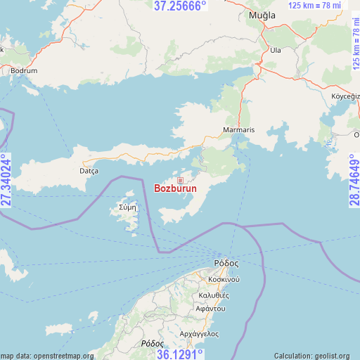
Bozburun GPS coordinates[2]
36° 41' 41.82" North, 28° 2' 36.096" East
| Map corner | latitude | longitude |
|---|---|---|
| Upper-left | 37.25666°, | 27.34024° |
| Center: | 36.69495°, | 28.04336° |
| Lower-right: | 36.1291°, | 28.74649° |
| Map W x H: | 125.4×125.4 km | = 77.9×77.9mi |
| max Lat: | 42.02683° ⇑95.5% North |
| Bozburun: | 36.69495° |
| min Lat: | ⇓4.5% South 35.9025° |
| min Long | Bozburun | max Long |
| 25.90902° | 28.04336° | 44.60099° |
| W 10.1%⇐ | ⇒89.9% E |
Elevation
Elevation of Bozburun is 1 m = 3 ft, and this is 716.4 m = 2350 ft below average elevation for this country.
| Max E: |
2682 m = 8799 ft | 100% |
| Avg. | 717.4 m = 2354 ft | |
| Bozburun | 1 m = 3 ft | |
Min E: |
0 m = 0 ft | 0% |
See also: Turkey elevation on elevation.city.
Geographical zone
Bozburun is located in North temperate zone (between Tropic of Cancer and the Arctic Circle). Distance of this Northern Tropic circle is 1474.2 km =916 mi to South.| Distance of | km | miles | from Bozburun |
|---|---|---|---|
| North Pole | 5927 | 3682.9 | to North |
| Arctic Circle | 3321.1 | 2063.6 | to North |
| Tropic Cancer | 1474.2 | 916 | to South |
| Equator | 4080.1 | 2535.3 | to South |


Nearby cities:
15 places around Bozburun: (largest is in red/bold)
• Bayır
65.5 km =40.7 mi,  13°
13°
• Bodrum
66.7 km =41.4 mi,  304°
304°
• Dalyan
55.8 km =34.7 mi,  73°
73°
• Datça
32.4 km =20.1 mi,  278°
278°
• Güvercinlik
64 km =39.8 mi,  320°
320°
• Karaova
56.8 km =35.3 mi, 323°
• Marmaris
27.2 km =16.9 mi,  49°
49°
• Menteşe
50.9 km =31.6 mi,  22°
22°
• Muğla
64.9 km =40.3 mi,  26°
26°
• Ortaca
66.2 km =41.1 mi,  75°
75°
• Sarigerme
59 km =36.7 mi,  87°
87°
• Ula
56.4 km =35 mi,  36°
36°
• Yerkesik
53.5 km =33.2 mi, 23°
• Yeşilyurt
59.1 km =36.7 mi, 20°
• Ören
38.5 km =23.9 mi,  349°
349°
Sources, notices
• [Note1] Compared only with cities in Turkey existing in our database
• [Src1] Map data: © OpenStreetMap contributors (CC-BY-SA)
• [Src2] Other city data from geonames.org with taken over terms of usage.
• [Src3] Geographical zone / Annual Mean Temperature by Robert A. Rohde @ Wikipedia
