Ula geodata
Ula (Muğla) is a seat of a second-order administrative division; located in Turkey in Europe/Istanbul (GMT+3) time zone. With population of 5,275 people, there are 700 cities with bigger population in this country. Compared to other cities in Turkey, 86.2% of cities are located further ↑North; 87.5% of cities are located further →East and 54.4% of cities have higher elevation than Ula. Note1


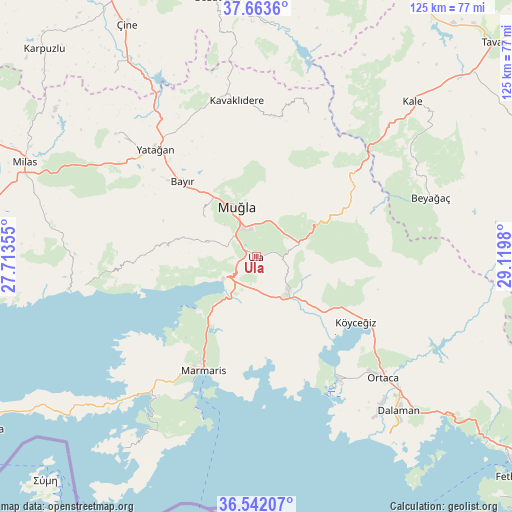
Ula GPS coordinates[2]
37° 6' 17.676" North, 28° 25' 0.012" East
| Map corner | latitude | longitude |
|---|---|---|
| Upper-left | 37.6636°, | 27.71355° |
| Center: | 37.10491°, | 28.41667° |
| Lower-right: | 36.54207°, | 29.1198° |
| Map W x H: | 124.7×124.7 km | = 77.5×77.5mi |
| max Lat: | 42.02683° ⇑86.2% North |
| Ula: | 37.10491° |
| min Lat: | ⇓13.8% South 35.9025° |
| min Long | Ula | max Long |
| 25.90902° | 28.41667° | 44.60099° |
| W 12.5%⇐ | ⇒87.5% E |
Elevation
Elevation of Ula is 606 m = 1988 ft, and this is 111.4 m = 365 ft below average elevation for this country.
| Max E: |
2682 m = 8799 ft | 54.4% |
| Avg. | 717.4 m = 2354 ft | |
| Ula | 606 m = 1988 ft | |
Min E: |
0 m = 0 ft | 45.6% |
See also: Turkey elevation on elevation.city.
Geographical zone
Ula is located in North temperate zone (between Tropic of Cancer and the Arctic Circle). Distance of this Northern Tropic circle is 1519.8 km =944.4 mi to South.| Distance of | km | miles | from Ula |
|---|---|---|---|
| North Pole | 5881.4 | 3654.5 | to North |
| Arctic Circle | 3275.5 | 2035.3 | to North |
| Tropic Cancer | 1519.8 | 944.4 | to South |
| Equator | 4125.7 | 2563.6 | to South |


Nearby cities:
15 places around Ula: (largest is in red/bold)
• Bayır
25.3 km =15.7 mi,  315°
315°
• Beyağaç
44.9 km =27.9 mi,  71°
71°
• Bozarmut
31.5 km =19.6 mi, 316°
• Dalyan
36.3 km =22.6 mi,  146°
146°
• Göktepe
37.1 km =23.1 mi,  19°
19°
• Kavaklıdere
38.1 km =23.7 mi,  352°
352°
• Marmaris
30.5 km =19 mi,  204°
204°
• Menteşe
13.4 km =8.3 mi,  275°
275°
• Muğla
13.3 km =8.3 mi,  340°
340°
• Ortaca
42.8 km =26.6 mi,  133°
133°
• Turgut
45.5 km =28.3 mi,  311°
311°
• Yatağan
35.7 km =22.2 mi, 317°
• Yerkesik
12.3 km =7.6 mi,  286°
286°
• Yeşilyurt
15.9 km =9.9 mi, 308°
• Ören
40.6 km =25.2 mi,  259°
259°
Sources, notices
• [Note1] Compared only with cities in Turkey existing in our database
• [Src1] Map data: © OpenStreetMap contributors (CC-BY-SA)
• [Src2] Other city data from geonames.org with taken over terms of usage.
• [Src3] Geographical zone / Annual Mean Temperature by Robert A. Rohde @ Wikipedia
